By Lizette Swart
Tracks4Africa is renowned for the reliability of our maps, especially off the beaten tracks, and people specifically marvel at the accuracy of the estimated travel times indicated on the maps. The T4A maps are compiled from GPS data submitted by the T4A community of travellers; people like you!
Travellers record their travel experiences and send it to T4A to process it in order to create a highly reliable GPS map which is also used on the T4A apps. Without your contributions, we cannot keep our maps up to date with the latest developments with regards to roads, travel times, points of interest, etc.
Have you ever wanted to contribute your tracks and travel information to T4A but didn’t know where to start? It is easy and your tracks, waypoints and information are most welcome and much appreciated! First of all you have to keep in mind, while you travel, what kind of information we need. Any place, spot or information that is important to you as a traveller will be useful and important to other travellers. Please share as much as you can as we use it to update our maps, as well as the content of our website, guide apps and self-drive guide books.
Information that we typically need is:
- Accommodation:
- The name of the establishment: please try and use the name and spelling as provided by the establishment in order to keep the T4A maps as accurate as possible.
- The type of accommodation: is it camping, self-catering, hotel, lodge, B&B, etc.
- Contact details: telephone number, email address and website, as well as other contacts available.
- Picnic sites: these can be official sites for day visitors or a place where one can stop next to the road to enjoy a sandwich and a cup of coffee.
- Community services such as police stations, hospitals, doctors and pharmacies.
- Other services such as supermarkets, fuel stops, towing service, mechanical workshop, a place to buy a sim card and airtime for your cell phone, a reliable butcher, etc.
- Entry gates and/or reception areas where you have to report or register.
- Toll gates and check points, e.g. veterinary check points, veterinary gates and permanent police check points where permits, etc. are checked.
- Warnings: e.g. the road is very muddy, very sandy, rocky, or meant for 4×4 only. We also need to know if you need to obtain a permit or have a guide for a trail.
- Permanent road closures.
- Points of Interest (POI) e.g. monuments, natural attractions, museums, etc.
- Your tracks or trip log: this we use to update the tracks on our maps. We also use your actual travel time that you travelled on this road to calculate the estimated time of arrival at a destination.
- Border Controls: info that is particularly important is the border opening and closing times, and also any other important info like costs, etc.
How do you record your tracks?
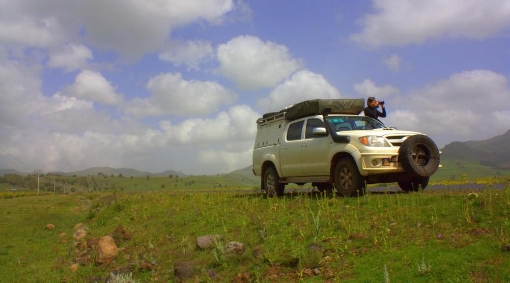
Always mount your GPS in the windscreen of your vehicle with a clear view of the satellites and if you really want to ensure that your GPS works well all the time, get an external aerial fitted.
In order to record the best quality tracks and waypoints possible, you may need to make a few adjustments to your GPS.
The “LOCK ON ROAD” setting under Setup > Routing must be switched OFF at all times.
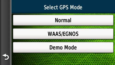
The Nuvi 300 and Montana 600 series GPSs have a WAAS function. As WAAS satellite coverage is only available in North America, this function should be disabled when you travel Africa. Go to Setup > System > GPS > Normal (not WAAS).
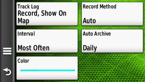
Under Setup > Tracks the settings should be as follow:
Track/Trip log recording must be ON.
Interval must be set to Most often.
Auto Archive must be set to Daily. (The GPS will then record your track log every day and store all the waypoints that you have made in a separate file per day.)
Never save the current track yourself, as only about 10% of the recorded points are saved this way. If you are doing an extended trip and you are concerned about running out of recording space on your GPS, download your GPS data daily to your laptop.
How do you record waypoints?
- You should not create a waypoint while you are driving, as it can be out with hundreds of metres and it is not safe to work on the GPS while you drive.
- It is better to provide less waypoints that are informative and useful rather than hundreds of waypoints with virtually no meaning. Marking a police station is great but making a waypoint for an elephant graveyard does not mean much as the elephant bones might be gone before the T4A map is next updated.
- Always ensure that you have the correct spelling in each waypoint that you create, in order to keep our maps as accurate as possible.
- If possible, categorise your waypoint e.g. Viewpoint, Shop, Lodge, Camp etc.
- Give a short description if possible. For instance, if it’s a little kiosk in the middle of nowhere, list some items it sells eg. cold drinks, beer, chips.
- Give contact numbers where possible, like for a tow-in service or a clinic.
- When plotting a waypoint for a fuel station, please note if petrol and/or diesel is sold.
How do you submit your data to T4A?
Firstly, join the T4A community. This is a fairly simple online process – go to https://tracks4africa.co.za/community/join/.
Now download the data (waypoints and tracks) from your GPS to your computer via BaseCamp (or Mapsource).
You can now edit your data if you need to, e.g. you may want to correct spelling, or add “camping” etc. to the name. Under comments you may want to provide some information such as “open 9am to 5pm”, etc. Please don’t alter any of the tracks, and don’t move any waypoints, as this affect the authenticity of the data. Rather make a comment in the email when you send the data to us and our mapping department will make the necessary changes.
If you have any routes saved in the file, delete the routes before submitting the data as the T4A server does not accept routes into storage and your file will thus not be uploaded. Routes are the routes that you created in planning your trip while Tracks are the recorded tracks during your trip.
You are now ready to send your data to T4A! This can be done in one of two ways:
- Send an email to newdata@tracks4africa.co.za and attach your file. You can make any comments in the body of the email to draw attention to specific things you would like to point out.
- Alternatively, upload your data to our website: https://tracks4africa.co.za
Other useful information
When travellers research a place to visit, they like seeing photos therefore pictures of accommodation establishments and Points of Interests are very useful and displayed on our website, the Africa Guide on your GPS and our Guide App.
Once you have registered with T4A, you can upload your pictures for a specific POI once the POI is added to our database.
Alternatively you can email the photos to newdata@tracks4africa.co.za in low resolution. Please ensure that you clearly identify the specific POI, with a short description, so that we know to which POI your photos belong.
If you have the latest pricing information for an establishment, you can please update this information on our website by searching for the POI and then correcting the Rates and Payment or email it to newdata@tracks4africa.co.za.
If you have any problems with submitting your data you can contact our support team at sales@tracks4africa or 021 880 8660.
