Thinking about exploring Zambia on a motorbike? From stunning views of lakes to the most incredible waterfalls, it is an experience not to be missed. By Tim Tucker and Carolyn Williamson
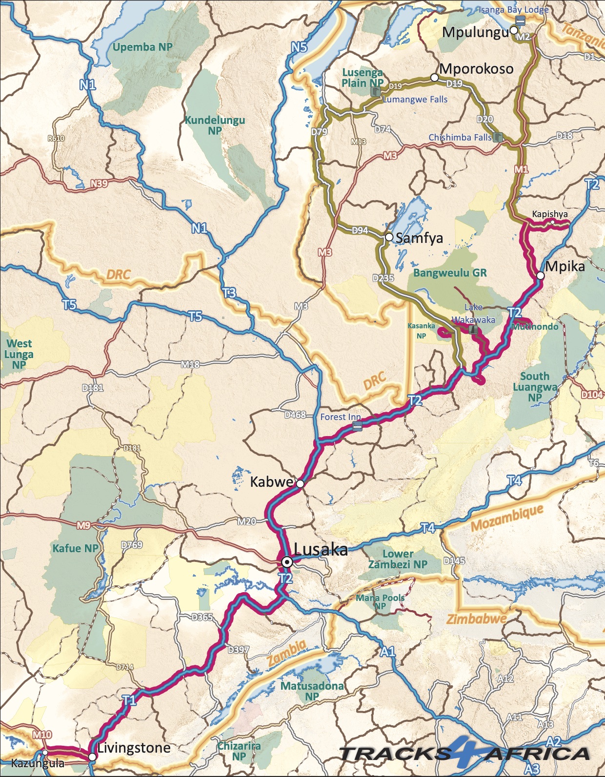
From Kazungula Border Post, our motorbike trip through Zambia took in Kasanka National Park, Lake WakaWaka, Mutinondo Wilderness and Kapishya Hot Springs before heading further north. Read more about the first leg of the trip in “Zambia on two wheels 1”.
Lake Tanganyika
We said our goodbyes to our fellow travellers, Malose Mamashela and Andrew Brown, at Kapishya Hot Springs. Then we headed north on the lovely M1 towards the regional capital, Kasama, and from there to Mbala. The two GS 1200 bikes purred up the beautiful tar road (mind the potholes). But we are always keen to get off onto the dirt. Mbala is on the high ridge above Lake Tanganyika, and there is a stunning drop on the M2 to Mpulungu. Situated at the southern tip of Lake Tanganyika, it serves as a major shipping port. A fascinating array of trucks and traders gather to ensure their products get transported north to DRC, Tanzania and Burundi on the various ships that traverse the lake.
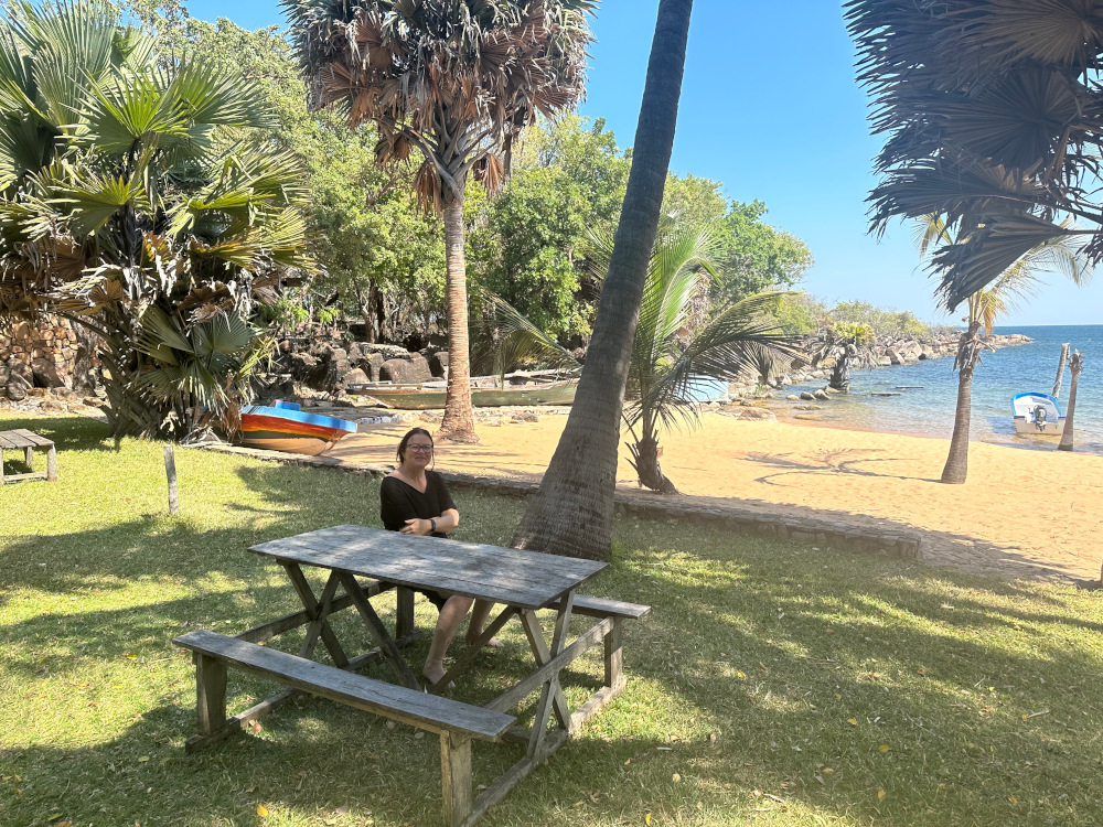
We wanted to climb up to Kalambo Falls, and so needed to stay somewhere in Zambia near the southernmost point of the lake. Finding out where to stay was challenging after our wifi data package ran out. But along came an angel in the form of the manager at Nkupi Lodge, Charity, who gave us access to data and a cold beer. With her assistance, we were able to book at Isanga Lodge, leaving our motorbikes under her care at Nkupi Lodge. She also does a fantastic laundry service, which we were very grateful for after riding through dust for approximately 2,000km by that stage.
Idyllic Isanga and Kalambo Falls
Isanga Lodge has new management, and is a real treat. Set on the southern shores of Lake Tanganyika, one arrives by boat after a 40-minute ride. There is apparently a road in, but is reputed to be extremely technical and difficult. Since it has destroyed many tyres and other car/bike parts, it is not recommended. Isanga has all the appearance of a tropical island, together with beautiful palm trees, white sand, grass lawns, elevated chalets and a generous restaurant and bar. There is also a campsite. We hung out there for three nights, with evenings spent with a cold beer from the restaurant. As we watched the sun go down, otters played in the water around us.
On day 2 we went on a stunning hike from the lake up to Kalambo Falls, the second highest (continuous) waterfall in Africa. Kalambo waterfalls is also the site of a famous archeological site (which unfortunately we did not see). Recently, archeologists recorded the earliest evidence of structural use of wood here – from at least 476,000 years ago. What a life’s dream to see these dramatic falls that cascade 221m into the Kalambo River, which flows through thick forest to the lake.
The waterfall route
The next phase of the trip was seeing the waterfalls in the Northern and Luapula provinces. There are hundreds of significant waterfalls in Zambia on account of the high rainfall in the country. In these northern regions, rainfall averages more than 1,250mm per year. Some of this water flows north-west, ultimately reaching the Congo River, or southwards into the Zambezi. The waterfall route should be on everyone’s bucket list. Interestingly, average temperatures are rising and average precipitation is dropping by about of 2mm per year, thanks to climate change. All of this is changing the nature of local farming, disease patterns and tourism in slow motion.
Getting out west near Lake Mweru and the DRC border area took some time, as we had to backtrack to Kasama. Here we refreshed our stocks of food and other supplies and then headed north-west on the D19/20, a great tar road, to Mporokoso.
Chishimba Falls
Night one was at the first of the major waterfalls we elected to visit – Chishimba Falls – a few kilometres after turning onto the D20. Three successive falls (Mutumuna Falls, Kaela Rapids and Chishimba Falls itself) are located on the Luombe River – a stunning place to take a break. All three waterfalls lie within a short walk of the Chishimba Falls Campsite. It is a Bemba sacred place, and visitors are requested to refrain from unpleasant behaviour/language at the site.
In truth, wonderful as it is, the lack of showers and adequate washing-up facilities means that some may see this more as a picnic site than a campsite. But we loved it, and were happy to delay washing the dishes to the next night! We were able to take some water from the river to wash, but wanted to be sensitive to the local traditions, and did not swim. (Perhaps it would have been fine to swim.)
The next day’s ride to the small town of Mporokoso was a joy, and the local stores were good for bread and beer. We even found a bottle of single malt whisky! However, thereafter the road changes to pretty rough dirt all the way to Kabweluma. It was challenging and took a good few hours as we weaved on and off the road to find better riding lines. For those of you who hate sand, there was always a hard track through the sand and so entirely manageable, if you have the time. It was so worth seeing the north-western area in more detail and spending more time dancing through the dirt and sand on our bikes. (Every day felt like a multi-hour ballroom dance between the two of us as we weaved from left to right to find the best riding lines!)
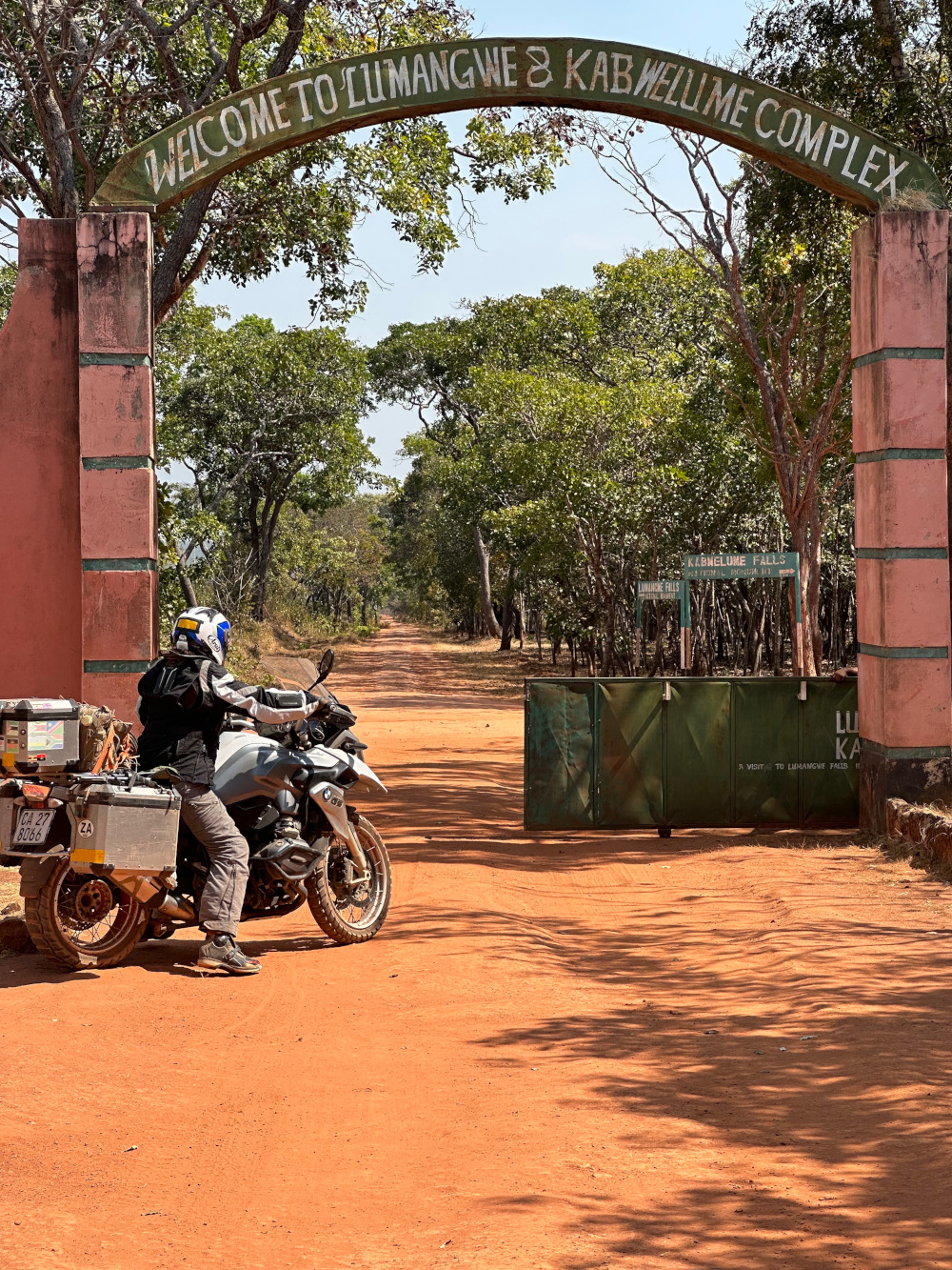
The spectacular Kabweluma and Lumangwe falls
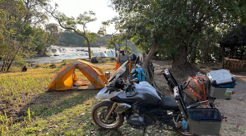
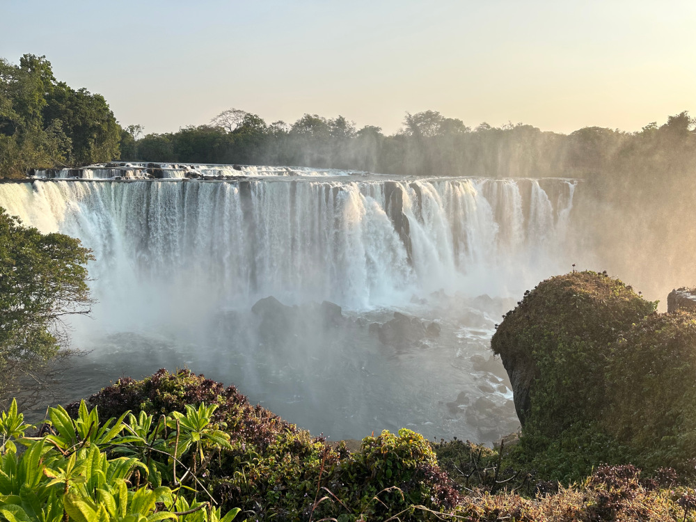
One of the absolute highlights of the trip was seeing the mighty Kabweluma and Lumangwe falls, which are located 6km apart on the Kalungwishi River. This large volume of water is a major contributor to the Congo River as it winds north-west through Lake Mweru and onwards.
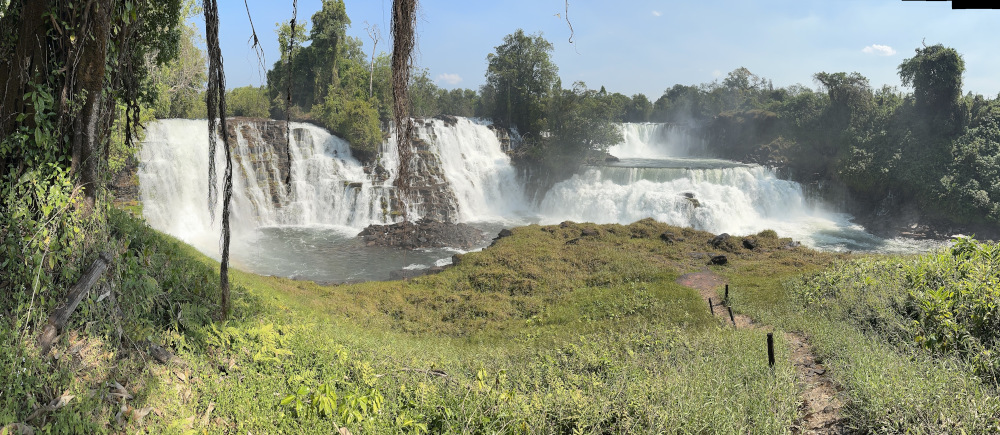
The 150m wide Kabweluma gives a sense of watching a mighty percussion orchestra cascading down in front of you. It is just so impressive! (Remember Robert De Niro climbing Iguazu Falls in “The Mission”… like that.) It is one of the most scenic waterfalls in Zambia and a must to see. Currently the campsite is closed, so have a day trip there and camp at Lumangwe Falls Campsite (main picture).
Then on to the spectacular Lumangwe, where we camped a few metres away from this “mini Victoria Falls.” We swam just above the falls as we arrived to ease the muscles after a long ride, and celebrated being in a place that must rate as being one of the most special we have ever been to.
There is a beautiful small stone path covered in green moss which you can use to walk to the base of the falls. There we saw the curtain of water extending 160m across.
The campsite, costing $15 per person, is simple and spotless with good ablution facilities. We were the only ones there, apart from a few day visitors. We fell into the tent on our thin blowup mattresses after a lovely evening spent watching the sun go down, trying to fathom out how we could be so lucky.
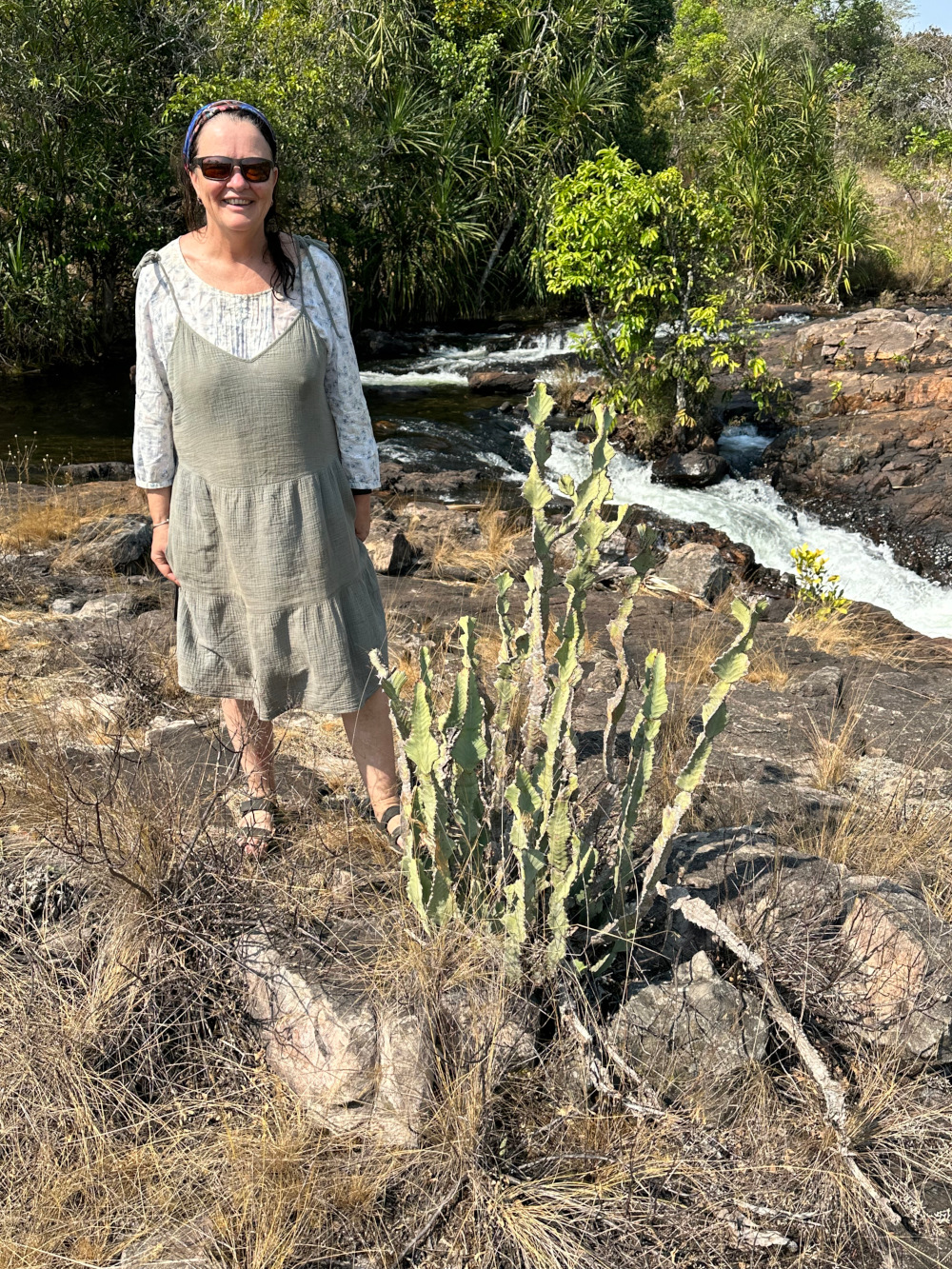
A special plant at Ntumbachishi Falls
The D19 road south from Lumangwe to Kawambwa was an excellent dirt road, seemingly recently upgraded. We danced our way to Kawambwa and restocked our various food and drink supplies. Kawambwa has a series of excellent bakeries and interesting small food shops. [Try Kawambwa Bakery or Queen’s Bakery. – T4A] We also picked up excellent meat to braai that night
The next evening was spent at Ntumbachushi Falls. This is a beautiful bridal veil-like final waterfall on the edge of the northern Zambian plateau, with a series of smaller falls above. It was an absolute pleasure swimming in the gorgeous crystal clear pools above that campsite. But in truth, it was very emotional and heart-warming getting to rediscover the small area of Euphorbia williamsonii that remains. This plant species was named after Carolyn’s dad, Graham Williamson. He is remembered fondly as one of Zambia’s most prolific botanists (and a dentist). Carolyn stood next to them, a proud “williamsonii”, remembering being there as a child. This small, 1m tall, branching (not very pretty) euphorbia only occurs just beside this one river. Its habitat is a few square hundred metres on rocky quartzite surfaces above the main waterfall. Fortunately, even though it is so small in distribution, it appears to be thriving.
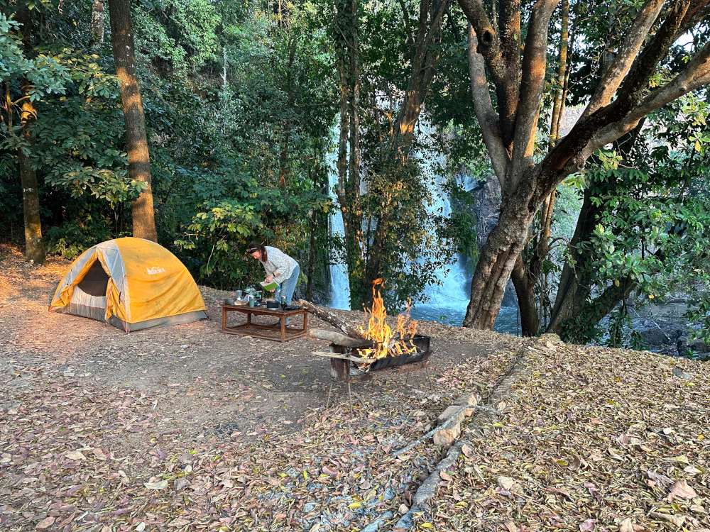
We celebrated our time by camping right next to the main waterfall, drinking to the memory of Graham and enjoying Mosi beer, steak and fire-roasted potatoes.
Heading south over Bangweulu swamps
The next section heading south towards Samfya at Lake Bangweulu is beautiful, passing through endless villages. The route includes an elevated causeway across the floodplains and the 2.5km-long bridge across the Luapula River. The D235 back towards Kasanka should have been easy. But it is severely damaged over (perhaps) a hundred kilometres as it works its way along the western aspects of the Bangweulu swamps. The road is elevated above the swamps, but something has changed in the last few years. Now the water (or other) damage to the road is substantial. As a result, the going is very slow, and will be for a long time. We had to weave from left to right to avoid potholes and trucks. The ride back past Kasanka onto Serenje was otherwise uneventful.
How long can we remain on holiday?
This was an incredible experience and these sights should not be missed. We wished we had more time. But, we had been on the road in Zambia for three weeks – with a further 3,000km to ride home. We needed to make a decision whether to head back slowly over a few more weeks, bringing out the laptops to work in specific places, or head back more rapidly. Not an easy call!
But after considering all the variables, we decided to head straight back. It was strange to get back onto the Great North Road with all its madness again after such a peaceful time on the more remote and minor roads, where riding is mostly a pleasure. However, we had no choice but to join that roller coaster as we headed back the same way through Lusaka. Fortunately, there is a ring road on the western side of the city. This dramatically shortens the experience of getting through Lusaka from north to south, which had taken many hours on previous trips.
The road continues to be a challenge until the turnoff south of the beautiful Kafue River onto the T1 which takes one down to Livingstone. Such a relief!
Also read: Zambia on two wheels part 1
All good things come to an end
We stayed in the commercial farming district town of Mazabuka at a B&B that was rather over-priced, but such a soft, wonderful bed and a massive breakfast fit for royalty. The next day, we headed over the Kazungula Bridge to the border point. We found crossing out of Zambia and into Botswana an absolute pleasure. 10 minutes! No fuss, no paperwork, nothing like it had been on the way in.
But by then, our headspace had changed. We were ready for Cape Town, family and friends. So we journeyed fairly rapidly through the Zambezi area, formerly the Caprivi Strip, (avoiding the elephants). We rode the length of Namibia and down to Cape Town, enjoying the magnificent spring flowers on display in the Northern Cape.
Zambia should be on everyone’s bucket list. There was a sadness in both of us as we crossed the Zambezi and left Zambia behind. It is a stunning country of stunning sites and even more stunning people. The limited number of tourists, beauty and generosity of the space is incredible. We just knew in our bones as that we would be back in the coming years to explore more. Take our advice – go there! You won’t be disappointed.
Explore Zambia with Tracks4Africa
Our Zambia Self-drive Guide Book has all the information you need to plan a trip to this country. In addition to descriptions of Zambia’s must-visit destinations, it includes comprehensive accommodation listings and suggested routes. The guide covers trip planning essentials such as vehicle preparation, border post red tape and road conditions. The Zambia Paper Map covers the full road network, including minor gravel and off-road tracks. Get the guide and paper map together in the Zambia Travel Bundle and save.

A most excellent blog T&C! What a fabulous adventure😃.
We agree, it is hard not to start packing immediately after reading about this trip.