Winding its way through kloofs and over mountain streams, Matebeng Pass offers superb views of eastern Lesotho. This landscape is worth the slow travel, but you have to know what to expect. By Chris Duvenage, with additional information from Gavin Fordham, Gavin Ogilvie and Greg Nelson
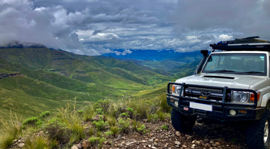
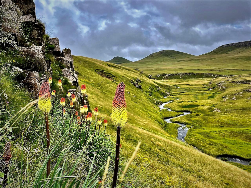
Mountain peaks that pierce the clouds. Silver streams that weave a ribbon between rolling green hills. A lonely road that snakes around mountain slopes in the vast wilderness. Matebeng Pass takes you deep into a part of Lesotho mostly untouched by development.
Eastern Lesotho is still very rural – you will find no big towns, no infrastructure, no shops. The people are friendly enough, waving as you go past and always willing to give directions. The few small villages are few and far apart. And while there are no decent roads, there are many mountain tracks. A lot of these are not shown on GPS maps and they could keep you busy for days exploring Lesotho. However, we had a very specific route in mind.
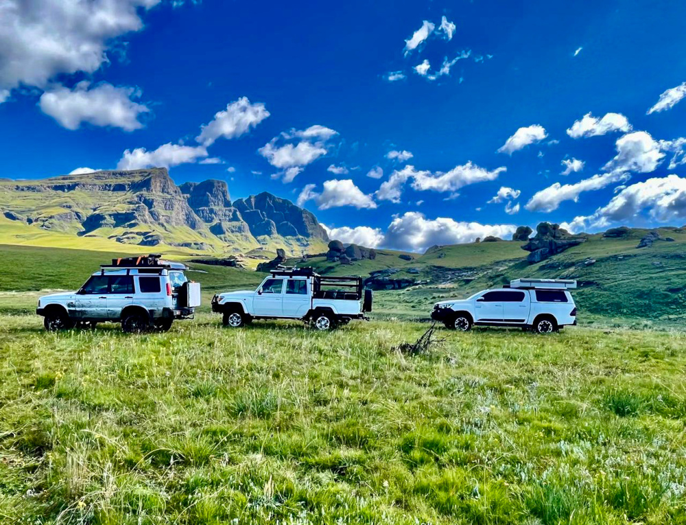
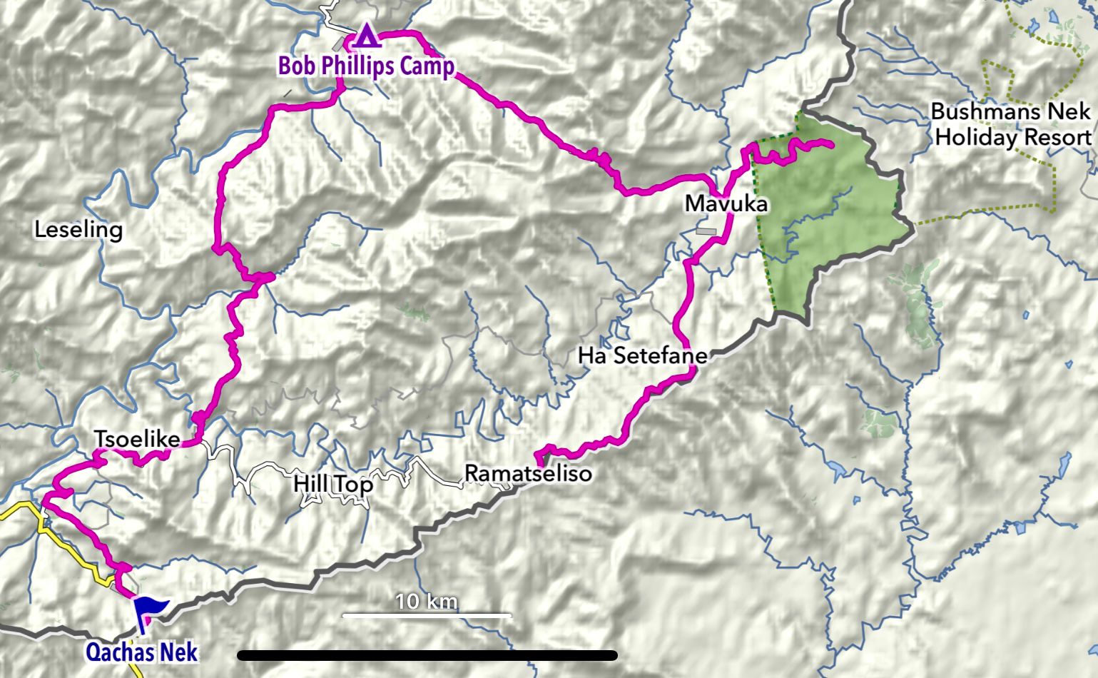
In February 2023, my family and I – accompanied by two sets of friends – headed up to drive Matebeng Pass. Our route led from Pietermaritzburg via the Lesotho border crossing at Qacha’s Nek to our first overnight stop, Bob Phillips Camp. From there we would follow Matebeng Pass to Sehlabathebe National Park, the second overnight point. On the way back to Pietermaritzburg we planned to go via Ramatseliso border post.
Getting to the start of the pass
Exploring Lesotho involves having a valid passport, but we found the border crossing straightforward. Aside from your passport and driver’s licence, you also have to supply the vehicle registration number, make and model. The officials were very friendly and the whole procedure was painless.
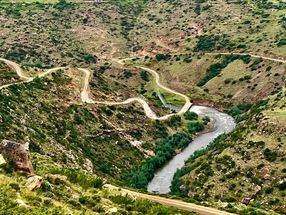
On the 95km drive from Qacha’s Nek to Bob Phillips Camp, we made our way via Tsoelike Weir. The road switchbacks up the mountain slopes and in under 1km we climbed 290m in altitude. It led through sparsely populated areas, with villages often consisting of only a few homesteads. It can be quite eye-opening to realise how remote and undeveloped these parts are. You won’t find fuel or ice here, but the landscape is scenic.
The campsite at Bob Phillips is formal, but only in the sense that you have to pay a fee of R20-30 a person. For all intents and purposes, this is wild camping, although there is a long-drop toilet. But it offers everything adventurers could want. It is a beautiful stretch of land along the Matebeng River shaded by weeping willow and poplar trees.
Driving Matebeng Pass
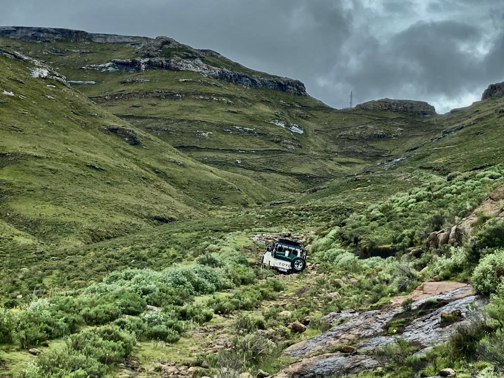
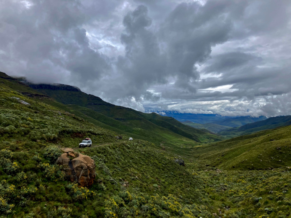
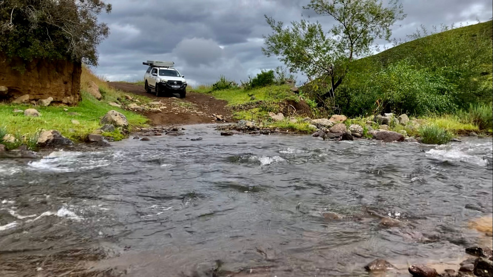
Matebeng Pass has a reputation for being one of the most challenging passes in southern Africa. It is one of the highest mountain roads in Lesotho and is gravel all the way. Loose stones and rocks are typical. Most of the way, the track is just one vehicle width, getting very narrow in parts. There are quite a few washaways along the route and since a new road was built, Matebeng Pass is no longer maintained.
The start of the pass is not far from Bob Phillips Camp and we set off at 08:30, allowing the whole day to cover the 38km distance. We drove the pass from west to east. The western part is historically considered the more difficult. The eastern section leads to a cellphone tower and is meant to be maintained. However, we found the eastern part is getting very eroded and washed away at the river crossings.
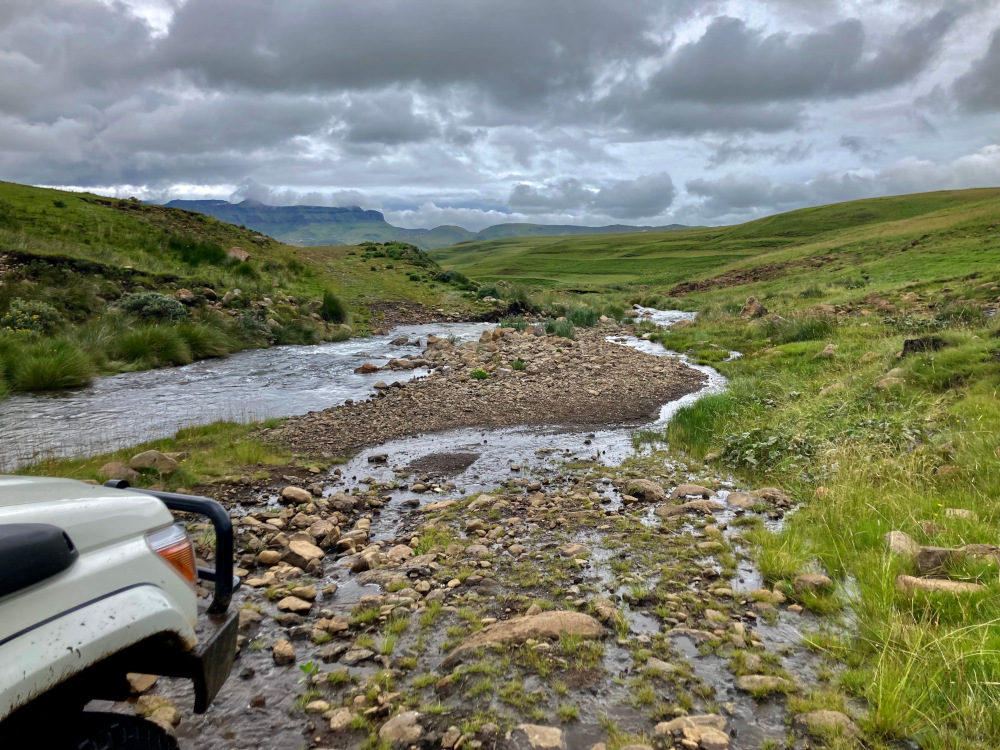
Summer is the rainy season in our part of the world and there had been a lot of rain in the lead-up to the trip. We knew we would have to contend with plenty of water and mud. This was the case: some stretches it felt like driving in a river. But all the water meant the route was very pretty, with many waterfalls and the landscape a vibrant green.
Wild and remote
Following a full day’s driving, we arrived at Sehlabathebe National Park, Lesotho’s oldest nature reserve. This park is so remote as to be almost inaccessible, but it’s wildly beautiful and truly serene. There is a stunning new lodge but we opted to camp with the Devil’s Knuckles as our view. Fresh, clean water flows through camp and it is possible to try your hand at fishing. You can buy a fishing licence from the park office on the way in. There is magnificent hiking in the area and it is possible to visit rock art that few people ever get to see.
After enjoying the isolation of Sehlabathebe, we exited Lesotho at Ramatseliso. All of us on the trip agree that it was well worth doing. Even though Matebeng Pass is a good challenge, we didn’t think the driving was overly technical. The scenery in eastern Lesotho was phenomenal and we loved the solitude up there.
Need to know before you go
How difficult is Matebeng Pass?
From a technical perspective it’s difficult to rate because people have varying degrees of experience. Looking at its deep ruts and rocky sections, Matebeng Pass can seem very challenging. But depending on your 4×4 experience the pass can actually be quite easy. Even though the road hasn’t been travelled much, we still found it very drivable.
We had a few sections where the road changed from a stony surface (where the grip was fine, even in the wet) to red clay. This required slow but steady momentum. If you slid off the track on a muddy section while going up a hill, it would mean a long day of recovery. There was also a section with steep drop-off to one side and a deep rut on the other. We picked our line correctly and had no problem, but a novice driver could make a mistake at this point.
You will need to use 4×4 for most of the pass and low range is beneficial. I find that at the altitude of Matebeng Pass (peaking at just over 10,000ft), high range is just too fast. In that extremely thin air, you could end up riding your clutch all day.
The pass has rough, big stones in places. You may want someone to guide you over rocky sections to prevent unwanted damage to your vehicle. If you take it slowly, you should be fine. My verdict is easy to moderate.
Can you do this as a solo traveller?
Matebeng Pass should definitely be done in a group of at least 2-3 vehicles. You need to have backup to tow you out if there is an issue. Some sections are very muddy and if you were on your own and got stuck, it would be a real problem. You really are in the middle of nowhere: everything in Lesotho is hours away. If you broke down, you might be stuck for 3-5 days. You would have to pay a huge amount for help to come from far away to assist you.
How much time should you allow?
Matebeng Pass took us 7 hours to complete. Don’t underestimate the amount of time it takes to explore Lesotho, all the roads are rough. It’s better to allow more time than you think you would need so you don’t put yourself under pressure. You don’t want to damage your vehicle because you are rushing to get somewhere.
When planning a trip in Lesotho, I reckon on travelling around 25km/hr in general. After all, you don’t want to rush. I would rather stop and get out, have a look around and take a picture. On those rural roads, you also often encounter breakdowns. Helping out another vehicle could easily take an hour or two.
The route
Where should you fill up?
There is no fuel available outside of major towns such as Qacha’s Nek and Ramatseliso. The best is to fill up in Matatiele before entering at one of these border crossings (including Ongeluksnek).
When is the best time to go?
Being a mountain kingdom, Lesotho is known for unpredictable weather. Even in summer you could easily have four seasons in one day. Getting closer to winter, a very cold snap all of a sudden is not uncommon.
I prefer the period March to May: those three months have the best weather. You avoid the big Berg storms in the afternoon and the misty days, but it isn’t too cold yet and still green everywhere. After that it gets very cold for camping, with minus figures every night. During a cold spell, temperatures of -8 to -12 Celsius are not uncommon.
In snow and ice, Matebeng Pass would become impassable. In the snow you wouldn’t see the track and ice would make it extremely slippery. In some places you might have to get out of the vehicle to build tracks and in icy temperatures, it would be a real challenge.
A lot of rain would also be problematic. Water crossings could become deep gorges and you could get to a point where you wouldn’t be able to cross.
Want to do a road trip along one of southern Africa’s iconic passes? Our GPS Maps offer turn by turn directions for the full road network – tar, gravel and sand. These maps for Garmin GPS units are downloadable or available on SD card.

I used to drive the Matebeng pass (sometimes solo) in 1974 when the pass was still under construction and the switchback corners had not yet been widened enough for a smooth turn. (had to back up once or twice on the turns) Also, stayed at a Food Aid Program (FAP) access track construction site near/at Bob Phillip’s Campsite with RMT (Bob) Phillips. Also stayed at another FAP at Sehlabathebe NP. Great scenery and some excellent trout fishing in the NP area.
It must’ve been quite an experience to drive that road before it was completed – thank you for sharing the memories.
A great adventure… one for the wish list
We did Matabeng in about 2000, March. The road was good gravel and plain sailing then. Now it looks considerably degraded. A great article, with thoughtful photos. Thank you.
Thanks for sharing your experience. Time takes its toll on the roads.
We drove this pass in April this year in our 6×6 camper truck, the other way round to you. Absolutely beautiful – we loved it – and saw a Cape Eagle Owl on the trail too! We camped on a bend on the way down towards Sehlabathebe.
That sounds like a really special trip, particularly with the owl sighting.
Two of us, each on a motorbike, rode this pass for the first time in the late 1980s.
We rode it a number of times over the years after that, and really think it is the best road I traveled on, during fairly extensive trips, through Lesotho.
Sehlabathebe is sadly, like so much of Lesotho, very different today, from what it was then.
What a remarkable experience it must have been. Thanks for sharing.
We also did it last year October 2022 and it was amazing. But time was not our friend. Having carelessly not updated our T4A we found our old T4A and Google maps going in different directions. So what was planned as a 5h30 trip from Semongkong Lodge to Bob’s Camp took a mammoth 12 hours. We drove from east to west and arrived in the dark descending “the more difficult” west half way in the dark.
But we were met in the dark by a very friendly Johannes (+266 5655 6174) who runs the camp with his wife Cicilla (+266 5016 5412). He has a small home in the rock face above camp and was only to happy to give a tour. He helped with Fire wood which was there when we arrived & washed our dishes in the morning for us. He wanted to show us rock art, but we unfortunately had to move on with limited school holiday time.
I am interested to know which route you took to Bob’s Camp. It looks like you started south at Tsoelike River (Tsoelike Weir not listed in T4A) and climbed north to meet the senqu river. Is this right?
Wish we had time for Sehlabathebe National Park :(…. Oh well there is always next time.
The kind of adventure you don’t want to have. Good it ended with a soft landing at Bob’s Camp – thanks for the feedback about the friendly service there. Chris’s map of the route has been added to the blog.