You can’t beat mountain passes for beauty, interest and excitement. When you circumnavigate Lesotho – the Mountain Kingdom – you get mountain passes for days. Keen overlander Willem Rudolph shares his route through South Africa’s mountains and along the Lesotho border.
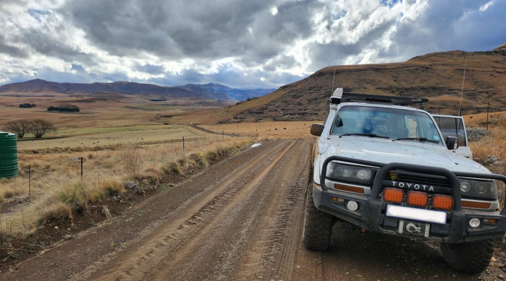
“Mountain passes are always interesting – both from a motorbiking and 4×4 perspective. There’s a vast range of things you can experience around the next corner. It could be an off-camber, narrow path around the cliff face. It could be a deep river crossing. It could be a massive, rocky climb,” says Willem Rudolph. “You also see more beautiful places when you elevate, because it gives you a vantage point over the countryside.” He experienced all of these aspects when he travelled along the Lesotho border, driving iconic mountain passes as he went.
Working in the oil and gas industry, Willem spent five years in the UAE before returning to South Africa in 2019. The first thing he did when he got back was to get an adventure bike, an old Land Cruiser and camping gear. Time away from home had made him realise the incredible diversity of the South African landscape. He couldn’t wait to explore it: on bikes with mates and in the 4×4 with his family.
The route around Lesotho had its origins in the pandemic. Although travel restrictions had been lifted, borders were still closed. So he sat down with his Tracks4Africa maps and plotted the closest possible route to the Lesotho border. “We did it in April 2021 on motorbikes and it was indescribable. You’re in the midst of the Maloti Mountains, the air is so clear. I knew I had to bring my family.”
A circumnavigation of the Mountain Kingdom
For this trip with the family, he again pored over the Tracks4Africa maps. “I can get lost in there. If you don’t stop me, I’d probably spend all morning with the maps generating rides and drives. For every trip, I calculate the percentage of gravel versus tar roads, because we don’t like staying on tar.” Excluding the transit legs to and from Johannesburg, 60% of this route is on gravel. Over eight days, it takes in four South African provinces and up to 17 mountain passes (some being optional).
At the beginning of the 2023 Heritage Day long weekend, Willem and his family set off on their 4×4 Lesotho border drive. They were joined by some friends and while the weather didn’t play along, everyone still had a good time.


Willem has kindly shared the route information.
Day 1: Johannesburg to Hobhouse
Distance: 450km
Gravel: 18%
This was all about getting to Hobhouse, the starting point of the route proper. Despite being mostly a transit day, there was the chance to stop off at the Fat Butcher in Ventersburg for biltong. One of the things Willem likes about Tracks4Africa maps is the wealth of Points of Interest (POIs). Once he has his route in place, he explores the POIs to find special places for a coffee or bite to eat.
“The last hour or so was on dirt and the trip really started coming alive as we saw the mountains in the distance,” he recalls. That night’s accommodation was at Don Don Rivermill Lodge, where stone cottages nestle close to a historical mill. Situated just metres from the Caledon River, which forms the border with Lesotho, the lodge is a serene spot.

Day 2: Hobhouse to Lady Grey
Distance: 232km
Gravel: 51%
From Hobhouse the real adventure got underway, with beautiful country roads delivering a sensory overload. “Travelling on the gravel roads, we could actually smell the fresh air outside. When we drove through a thicket of blue gums, there was an overwhelming blue gum scent,” says Willem.

The route wound its way through forgotten little villages and into the Eastern Cape. The quaint village of Lady Grey, with its venerable sandstone church, was the overnight stop. “We stayed at the Mountain View Country Inn, which I found on Tracks4Africa. By this stage we were next to the mountains and the anticipation was building, but this is where the rain really started coming down.”
Day 3: Lady Grey to Bidstone Cottages (Wartrail)
Distance: 124km
Gravel: 85%
Lady Grey’s location at the foot of the Witteberg Mountains meant it was time for mountain roads. Joubert’s Pass climbs quite steeply out of the village and because it had been raining, the surface was muddy and slippery. Willem cautions that there is no barrier, so it is best to take the pass slowly. “I’ve always wanted to do Joubert’s Pass and it did not disappoint. When we got to the summit, there were even snowflakes drifting down.” he says.
Having made it safely to the top, they drove down and had an impromptu coffee session to soak up the scenery. “Joubert’s Pass is one of the most beautiful things I’ve experienced: miles and miles of dirt road, little brooks and waterfalls, steep ravines and flocks of sheep by the side of the road.”
The road to Wartrail led via Wintersnek and Balloch’s passes, offering more epic views of wild mountain country. At Bidstone Cottages, Willem and his party were blown away by the hospitality, especially the wood-fired pizzas. Hosts Allan and Julz make everything on the farm: homemade pizza dough, free-range meat and organic veggies. “It’s the best pizza that we’ve ever had, plus they also do craft beer and craft gin.”
Day 4: Wartrail to Rhodes
Distance: 44km
Gravel: 93%
Bidstone’s setting on the Volunteershoek Pass makes it an ideal departure point to Tiffindell. But host Allan, an expert on the local conditions, was concerned that the rain would’ve made the turf track extremely slippery. So the overlanders decided to check out Lundean’s Nek Pass (also called Lundin’s Nek) instead.
Mountain Passes South Africa ranks Lundean’s Nek among the Eastern Cape’s great gravel passes. Across 14.5km, the pass winds through over 100 bends, corners and curves. At the top there’s a platform among the rocks where you can stop to enjoy the view. Having soaked up the vista, Willem and party went back the same way and then took a road along the foot of the mountains to Rhodes.


Time appears to have stood still in this little village, which still has dirt roads. So what the group lost in mountain views, they made up for by wandering Rhodes’s charming streets. This Victorian-era village has been declared a National Heritage Site for its well-preserved buildings. “When you visit the old hotel with its creaking wooden floors and heavy bar, it fills you with nostalgia. We stayed at Walkerbouts Inn – owner Dave Walker is a larger-than-life character and a fascinating source of knowledge on the village.”
Day 5: Rhodes to Matatiele
Distance: 220km
Gravel: 80%
From Rhodes the choice of route was obvious: Naudé’s Nek Pass, considered one of South Africa’s top mountain passes. The steeply winding pass intersects the escarpment roughly where the Witteberg, Maloti and Drakensberg mountains meet. “Driving it was one of the gnarliest, but most beautiful experiences. It was raining and it felt like we could be in Scotland. But there were some quiet moments in the Land Cruiser because of the steep dropoff and lack of safety barriers.”
Brunch at Tenahead Mountain Lodge with its picture windows and roaring fireplace was a five-star experience. It was also the highest point they reached on the trip, way up against the Lesotho border. And while it was challenging to get there, it was all worth it for the full English breakfast in luxury surroundings. But that wasn’t even the highlight for the day. “When you come down from Tenahead, you crest the escarpment and you see the entire landscape opening up. It’s similar to Sani Pass, with this zigzagging little dirt road leading down. That was really the highlight for me.”


When they stopped for a break, the overlanders met a farmer of the Naudé family who was responsible for the impressive pass. The group arrived in Matatiele just in time to purchase distinctive Basotho blankets. Functioning as a jersey, a jacket, a raincoat and a sleeping bag, a proper Basotho blanket features distinctive patterns that carry a lot of symbolism.
Day 6: Matatiele to Underberg
Distance: 175km
Gravel: 43%
Day six saw a mix of tar and gravel leading through farmland and into the Southern Drakensberg. This is the landscape that has made the Berg such a popular destination: sparkling lakes and rivers, rolling green hills and towering peaks that draw hikers and climbers. The roads, however, aren’t in the same class. “The tar roads are really shocking: there are so many potholes. Sometimes we’d see another vehicle come from straight ahead because they’re trying to avoid potholes. It would be better to get rid of the tar and just have dirt roads,” says Willem.
All the same, the drive through the countryside was beautiful, with hillsides so verdant, it hurts your eyes. “You’ve got to stop at the Olde Duck coffee shop with its tables under weeping willow trees and donkeys grazing alongside,” he recommends. The overnight stop, Lake Naverone self-catering cottages, was another find from the Tracks4Africa map. Situated on a secluded lake, the property offers trout fishing and access to hiking and mountain-biking trails. “You cannot describe the beauty of Lake Naverone, it’s the kind of place where you can spend a week.”


Day 7: Underberg to Champagne Valley
Distance: 208km
Gravel: 40%
The route on day 7 included two well-known roads: Lotheni and Nottingham. Gravel for the most part, these meandering roads wind their way north through the foothills of the Drakensberg. This part of the Berg is popular with holidaymakers and instead of lonely farmsteads, the group drove past resorts and golf courses. The change in the countryside was brought home as they crested the last pass. “On previous days, we would come over a cutting and look out over untouched landscape. This time, at the top of the pass, we saw houses and people. Our trip through the remote countryside was at an end.”
Willem suggests an alternative route would be to go up Sani Pass and through the north of Lesotho, descending to Clarens on the west. This would extend the time spent on lonesome tracks and preserve the sense of seclusion for longer. Lotheni Pass and Nottingham Road are beautiful but they carry a lot more traffic. The last night of the Lesotho border drive was spent at Dragon Peaks Mountain Resort, in the shadow of towering mountains.

Day 8: Champagne Valley to Johannesburg
Distance: 461km
Gravel: 6%
On the last day, a final stretch of gravel led into Bergville, but from there the focus was on getting back safely. The Sterkfontein Dam outside iNtabazwe (Harrismith) provided a last glimpse of stunning scenery, a moment of wow before heading home.
Map of the Lesotho circumnavigation

Willem’s travel tips
- It is best to do this route in convoy as it travels through remote areas. If you slide off into a gully, it’s helpful if there’s another vehicle to winch you out.
- A satellite phone is highly recommended. They can be hired if you don’t want to go to the expense.
- Focus on the experience. It’s not about getting there, it’s about what you see along the way.
- Leave early enough to cover the day’s distance (usually around 200km) with ease. You will be travelling no faster than 40-50km/h for long stretches and you don’t want to get in after dark. It’s more enjoyable to arrive in the mid-afternoon and enjoy the sunset with a drink in hand.
- Travel during the shoulder seasons: March–May and August–October. It’s more likely to be dry and the weather is usually not extreme.
- Be aware of where you can fill up and how far you can go before the next filling station – the Tracks4Africa map set shows fuel stops. Load shedding may mean you can’t refuel at your intended stop (unless you’re willing to wait four hours in some cases).
- Always carry enough water and food to see you through a couple of days.


loved this post, thank you. i would like advise please – we want to do a similar route , but to include a drive up sani pass and through lesotho. (not the rainy season ) two vehicles – a toyota hilux 4×4 and a vw transporter 4 motion. i have done many off road with the 4 motion which i find very capable but advise for this route would be appreciated. thanks
Hi Cecilia – If you are planning to stay on exactly the same route that was described in the post, then you may well make it with the 4Motion. The issue being that we abandoned driving a few of the most significant “must-do” rough gravel passes because of a spell of inclement weather that rolled in while we were in the area. The original route will take you up Volunteershoek Pass and down Carlisleshoekspruit Pass, into Rhodes on the other side. (I would not suggest attempting the alternative which is called the TTT or Tiffindell-Tenahead Traverse in any vehicle at this time) and this is where the need for a high-clearance 4-WD vehicle becomes key. I have taken a look at images of the 4Motion and based on what I am seeing, you may struggle with the lack of sufficient ground clearance. I obviously don’t know the specific details of your 4Motion and if it has been modified in any way, but you will be in for some steep and rocky ascents and descents, which may be short in distance but are challenging in complexity. Having said all of this – I always recommend getting a view from the locals, and as it goes, the owner of Bidstone Cottages (Allan) is located on the Volunteershoek Pass itself and is deeply involved in the maintenance of the pass. (He is also a super host and makes the world’s BEST pizza’s). He will be able to advise you more accurately on the pass conditions and the viability of taking the 4Motion up to Tiffindell via Volunteershoek. You can reach Allan on 084 603 0883, but you may need to send him a WhatsApp as I am not sure of signal strength in that area.
What an insightful journey into the cultural significance of Basotho blankets! From their humble beginnings as a practical solution to ward off the cold mountain weather to becoming a symbol deeply woven into the fabric of Lesotho’s identity, these blankets truly embody the spirit of resilience and tradition. It’s fascinating to learn about their evolution over the years and how they continue to play a vital role in various ceremonies and everyday life events. If you’re planning a trip to Lesotho, be sure to explore Moetlo for some Basotho-inspired fashion pieces to truly immerse yourself in the rich heritage of this beautiful country. Check out http://www.moetlo.co.za for a stunning collection of Basotho-inspired clothing and accessories!
Chatted to Andrew this morning and he mentioned this recent T4A Blog. Great read and some great pictures. Need to plan a trip out there sometime soon.
Amazing trip! Willem, you are an excellent route & trip planner! Looking forward to many more in the future!
fantastic trip. must do!!!
Those mountain views are hard to resist!