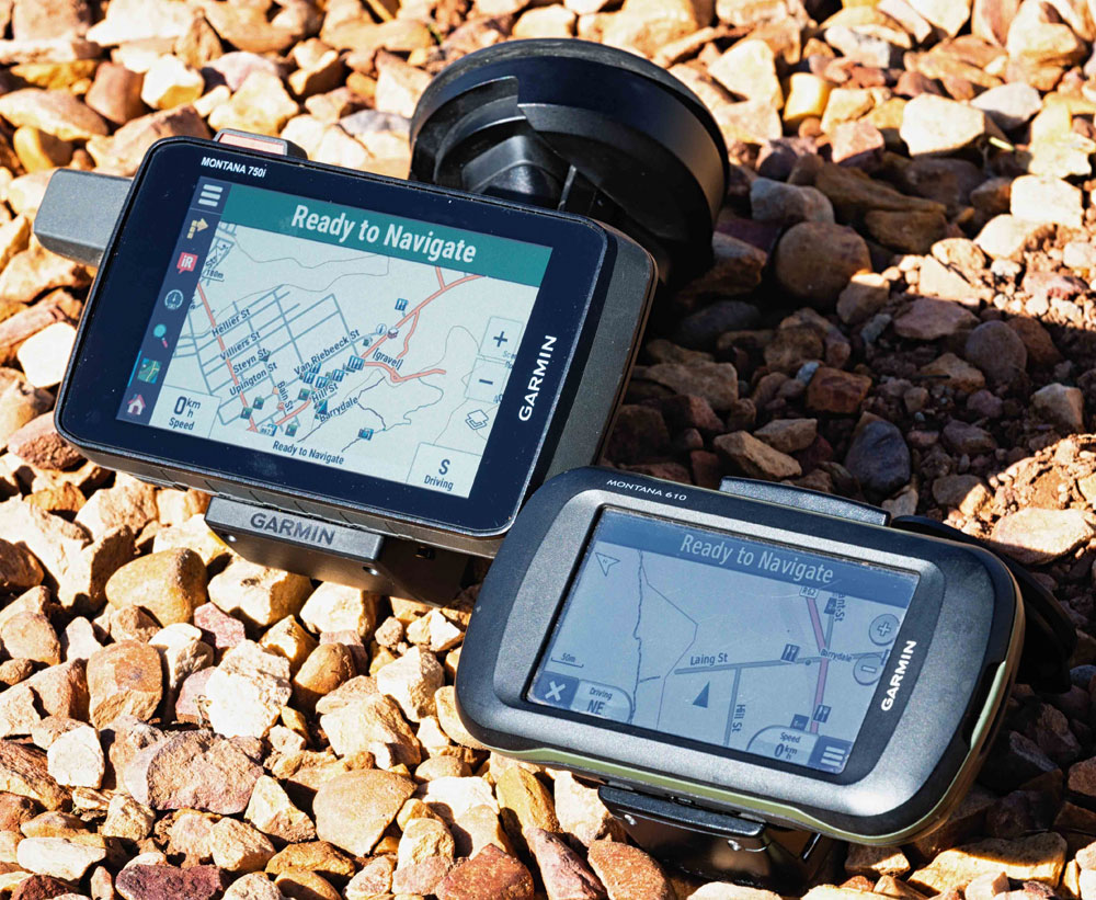
Where better to test the Garmin Montana 750i than Namibia? This is how the GPS navigator stood up to the challenges.
I have been able to use the Garmin Montana 750i for quite some time now and it accompanied me on a two-week trip to Namibia recently. The unit was used for overland travel and was exposed to heat in the vehicle. Badly corrugated roads also tested the mounting system to the extreme.
How I use the Montana 750i on a typical trip
I think it is important to consider the use case in order to put my comments into context.
My mode of travel is by 4WD vehicle and the unit must be fitted to my windshield in order to be visible. I also need to power the unit up while using it.
I like to plan my trips using Basecamp. I use the same map on Basecamp as I would use on the GPS. This is an important consideration. I usually convert my planned routes to tracks in Basecamp and will transfer waypoints and tracks to the GPS.
Once on the trip I want the GPS to record my trip continuously so that I can have an archive of my trip. I will import the planned tracks (converted from routes) and make them visible on the map. Then I set the track colour to something that is easy to distinguish from the background.
I will set routes per destination as I travel. The tracks act as a guidance and routes will be used to obtain trip information like ETA and distance to destination.
I also like to browse the map for places of interest along the way.
Once I am back from a trip, I download the track recordings which are used for various trip reporting tasks.
How does the Montana 750i serve my needs as an overlander?
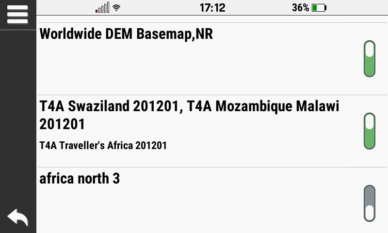
The ability to load custom maps allows me to use our Tracks4Africa maps on Basecamp and on the GPS. My process involved using the Garmin MapInstall application on my Mac computer to select the maps I want to transfer to the device. You would also be able to insert our plug and play SD card and bypass the MapInstall process.
I am able to send data to the GPS by browsing the internal memory of the device. It is easy enough to simply copy a GPX file to the internal memory of the device and use this data. The Montana range carries on from where the 600 left off as a true outdoor unit in this regard. I could connect the device to my Mac laptop, however, Basecamp always gives an error when trying to read the device, so I simply copy GPX files across.

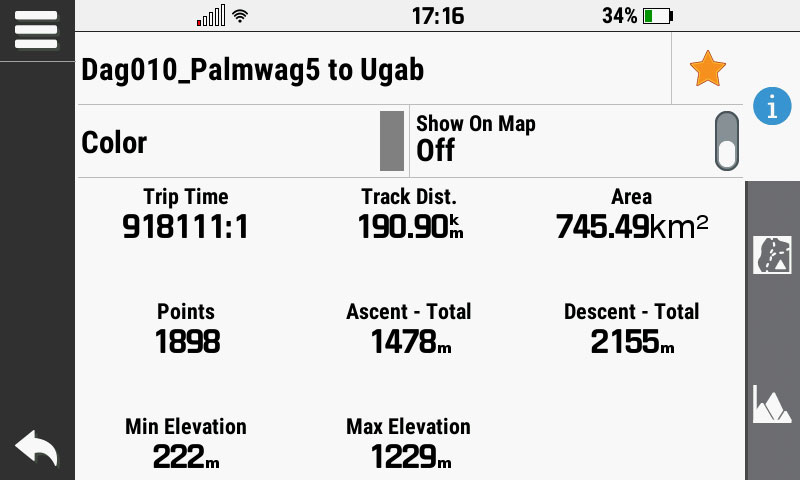
On the GPS I use the Track Manager to display the tracks that I imported to the Montana. This is a great feature of the device.
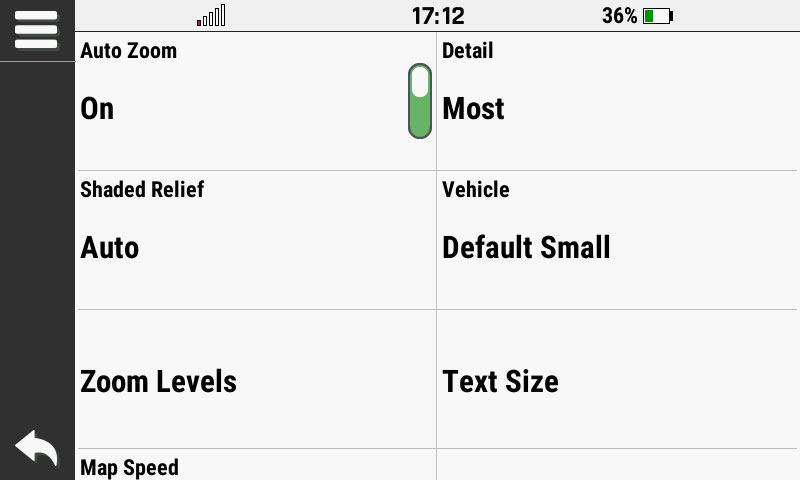
I can also set up the map to show certain map data at specified zoom levels. This is a great feature carried on from the very old 276c throughout the real outdoor units like the Montana 600. I am happy to see that this has been retained in the Montana 700 series.
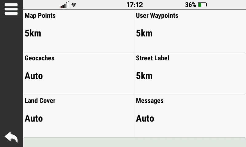
More about map detail
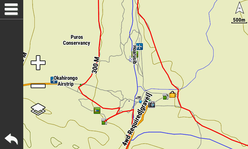
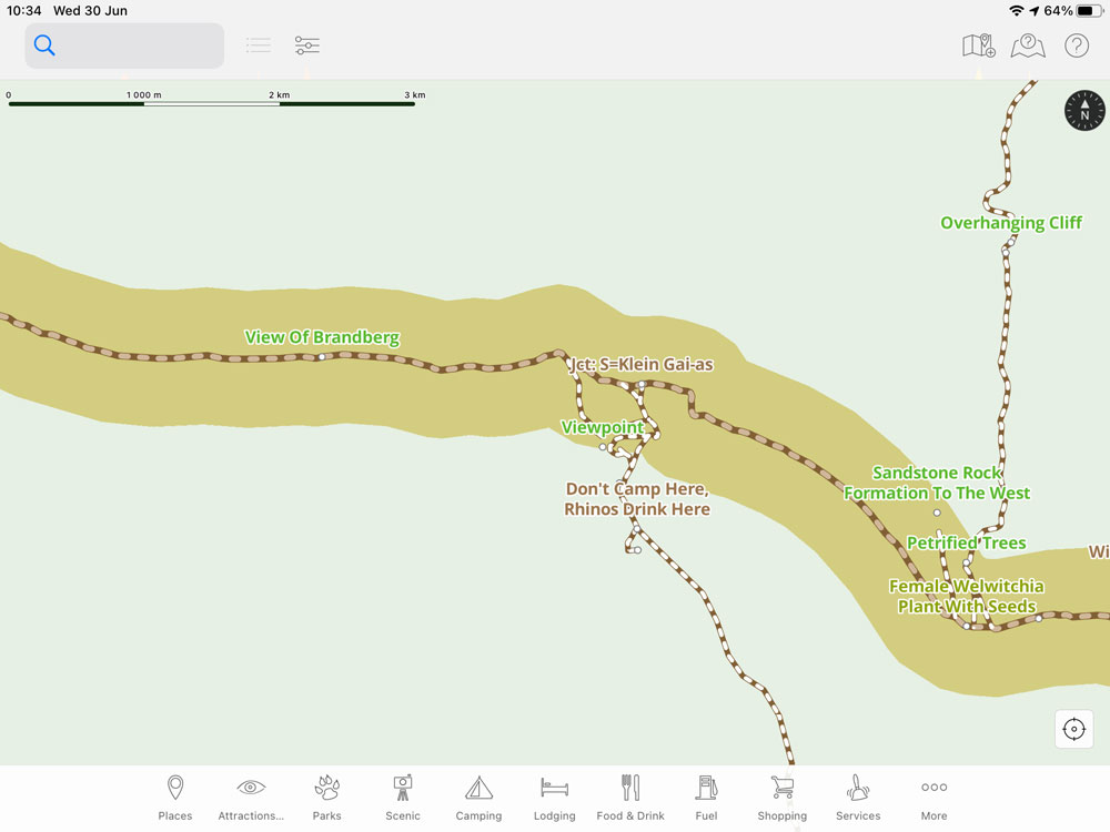
Apart from the zoom levels, you can also set the Map Detail. This, together with the zoom levels, allows me to force more detail onto the map, which is especially handy in remote areas. However, the map is still not perfect for exploring places around you and for this I find our T4A Guide App to be much better. It allows me to easily zoom in on the map and see map points together with their names displayed.
Here is a comparison of the same area on the Garmin Montana GPS vs the T4A Guide App:
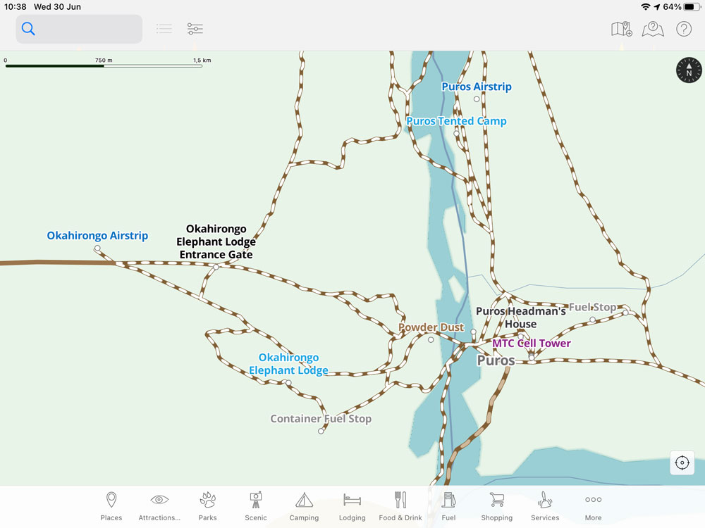
On the Guide App it is possible to get an overview and quickly zoom to the detail and see what is around you.
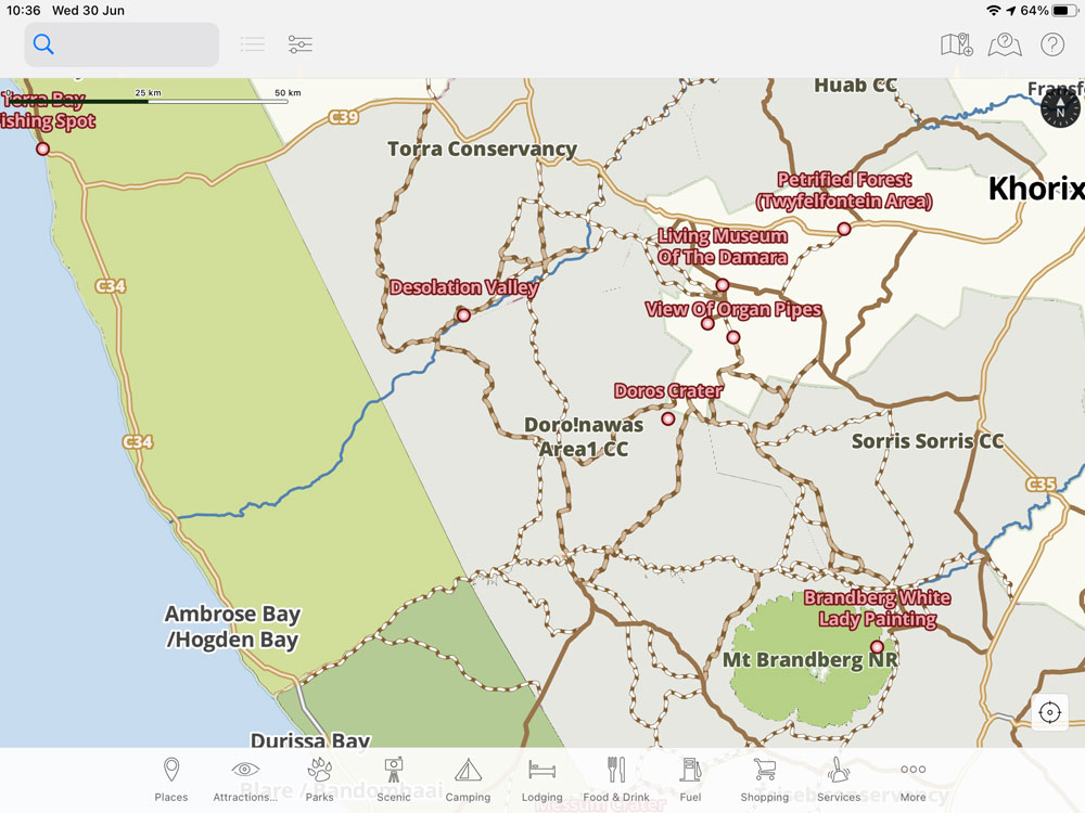
Note how map points show up with their labels shown.
Tracks and routing
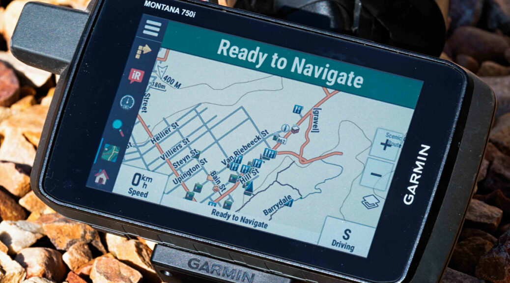
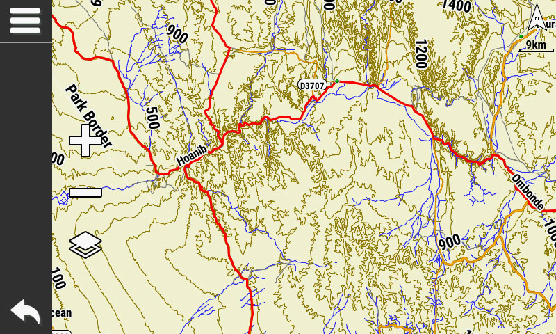
The auto routing on the Garmin Montana is pretty much the same as on any other Garmin GPS. I normally use Fastest Time and I always ensure that none of the Avoidances are set. In some cases, I may use Shortest Distance but my guide remains the pre-planned track that I load to the GPS. This allows me to quickly compare the route calculation to the pre-planned trip. In the image below I have uploaded a track and made it visible on the map, choosing red as the display colour.
Back at home I am able to download my tracks from the Montana. I usually do this by connecting the GPS to my computer and browsing the internal memory. I will make a complete copy of the GPX folder of the GPS and then import the GPX files I want from here to my trip folder in Basecamp.
What is my overall opinion of the Montana 750i?
I really like the Garmin Montana 700 series. It replaces the very popular Montana 600 series, which has been my favourite Garmin GPS up to now.
The Montana 700 series includes the same outdoor features as the older 600 series and there are numerous additional features added to the new units. I think this unit is very good for overland travel and will most likely become my replacement unit once the Montana 610 gives out.
The Montana 700 series will be equally at home as an adventure bike GPS or on your boat. While a bit on the larger side, you could also use this GPS for hiking and MTB. My favourite GPS for hiking and MTB remains the Garmin eTrex22 though.
On the hardware side, the Montana 700 series comes with a bigger screen (5 inch) than the old 600 and the quality of the screen is also much improved. It is still a touch screen unit which trumps the GPSMap 276cx in this regard. I really do like the new form factor of the Montana 700. The Garmin Overlander and new Garmin Tread units are both very large units which will take a up a lot of space on your dashboard. If these two units boasted better outdoor features, I would have considered them, but for me the Montana series is a better package. This is especially true if you plan to interchange the GPS on your bike and 4WD, or even MTB.
How to mount it
The Garmin Montana does not ship with a mount and it does not have a built-in speaker. There are several different mounting options to suit the various applications of this GPS.
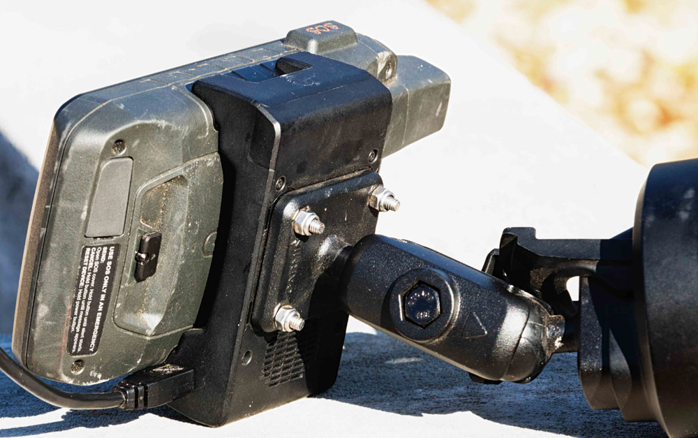
For mounting the GPS in your vehicle and to get audio output from the unit, you need to buy the suction cup mount with speaker (010-12881-00). The mount is very rugged and has a quick release button to remove the GPS without having to remove the mount. The only downside to this mount is that the power cable connects to the mount with a USB connector, which I don’t think will last too long.
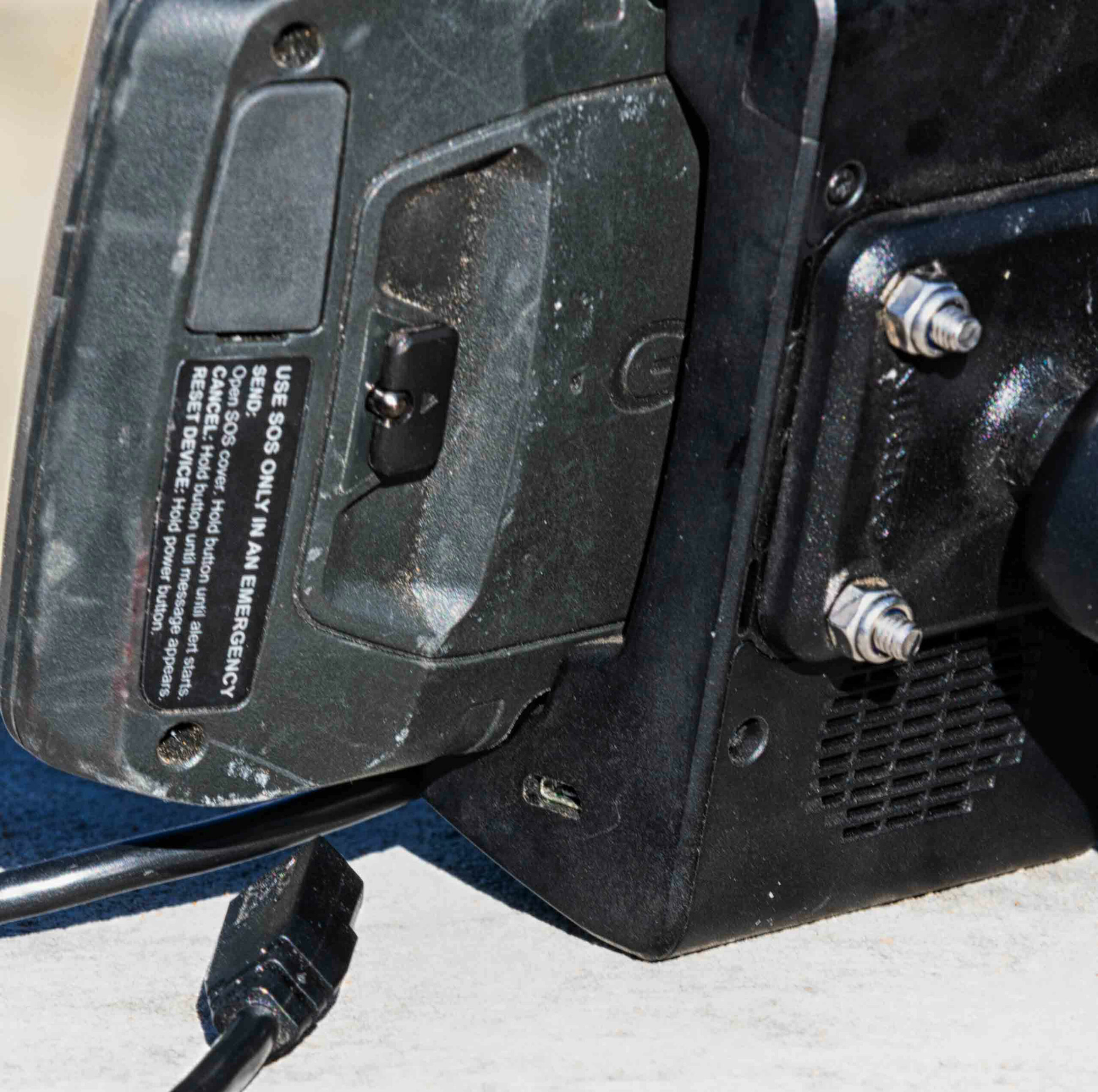
There is also an ATV/Motorbike mount which does not include a speaker, but the power cable is hard wired into the mount and the wires are left bare (010-12881-03). This allows you to permanently wire the mount to your motorbike. I would rather buy one of these mounts and attach a DC plug for use in my vehicle. Or simply hard wire it from your vehicle’s ignition circuit. The cable includes an audio out wire, so if you want you can still hook this up to a small speaker to get voice commands. However, I actually prefer not to receive voice commands from the GPS when travelling overland.
Then there is also a bicycle handlebar mount available for this GPS (010-12881-01). It does not have a speaker or power cables, providing the bracket only.
All of the mounts are compatible with RAM hardware, making for a very versatile and rugged set of mounting options.
How this GPS uses inReach technology
What does the ’i’ stand for? You might have noticed that the Montana comes as a 700, 700i and 750i model. The ‘i’ at the end of the latter two units stand for inReach. This is the satellite communication technology found in the Garmin inReach units, now built into these Montana units.
I did not test this feature of the Montana but the technology itself has been around for a while and is solid. I have an inReach Mini which I pair with my phone for this type of feature. For those who do not know, inReach allows you to send and receive text messages via satellite communications. This makes it a very handy tool for remote travel. There is also an SOS button on the unit which will send your distress signal and location to a dedicated call centre from where they will coordinate emergency response with local service providers. The inReach services come as an additional subscription.
Also read: In touch with Garmin inReach
Which Garmin Montana model to get?
There are three different models to choose from:
Garmin Montana 700 (010-02133-04)
Garmin Montana 700i (010-02347-12)
Garmin Montana 750i (010-02347-02)
If you want the inReach technology, then you have a choice between the 700i and the 750i. The difference between these two is essentially that the 750i has a camera where the 700i does not have one.
If you want Garmin’s City Navigator maps then it is important to note that the 700i and 750i both come with lifetime maps included. The 700 does not have any maps included.
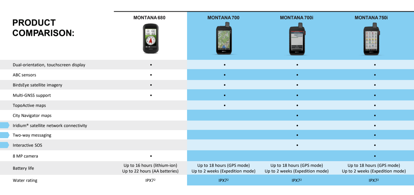
Another consideration for me is that the 700 has the ability to be used with 3xAA batteries. It comes standard with a rechargeable battery which should be your default choice, but it is great to have the option to use the unit with AA batteries if need be. There is a separate AA battery pack (010-12881-04) that you need to buy as an optional extra to use this feature though. The 700i and 750i only have the option of a rechargeable battery which can be removed. You would then technically have the option to carry a second rechargeable battery (010-12881-05) for these two models.
My personal choice would be the Montana 700 as I already have the inReach Mini and I prefer the option of using the device with AA batteries. The Montana 700 is also the most affordable of the three models. For drivers who want the City Navigator maps as well inReach technology, I would recommend the Montana 700i.

Hi Johann. I hear that the biggest problem with basically all the new generation real off road Garmins are that you cannot stack two or more map layes anymore. That is a very big deal breaker for me because I have a essensial transparent layer map that I always stack on top of the auto-roatable road basemap like the Tracks4Africa maps as base map. The top map is basically just visual information (power line tower detail) that I use for my work but to much information to store as waypoints. We are talking over 100 000 tower names/numbers plus the power line names too. That is really bad news. So while my good old trusty Montana 650 (broken top on off buttons and all) still works I don’t see the new 700 series as a real usefull upgrade. Can you may be please confirm that two or more map layers at once would not be posible anymore. The top maps being a transparent map layers and the bottom map the road map.
Johan, send me a typical overlay IMG and we can test this for you. You know where to find me…
Johan sent me a transparent IMG to test on Monatan750. For the benefit of the readers I would like to report that this did work on the Montana750. I had Tracks4Africa map as well as a transparent IMG switched on at the same time and could see the overlay data on the screen.
I bought the 700i. Endless trouble with the mount. The volume is barely audible, it never charges the battery because of an overheating issue and I think the USB is flimsy. GPS unit often just turns its self off and the only way to get it on again is to remove the battery. Also does not speak waypoint or street names and has no speed camera or limit information on the screen. NOT THE BEST GPS I’VE EVER HAD.
Hi Tim, I agree that the vehicle mount requires a better power solution. The USB will most definitely not stand up to vibration. I would therefor go with the bare wire mount which one can permanently wire to the vehicle and potentially put a DC to DC plug in line that is more sturdy. I personally do not bother with voice commands, so the speaker is lost on me. The bare wire mount allows for a audio cable which can be connected to a better speaker I guess. As for software issues, I trust that this will be sorted with firmware updates, unfortunately this has become a feature of newly released hardware.
I replaced my 600 series Montana with a 700i. Did certainly not need a camera as well.I have found it to be an excellent GPS. The only gripe is the bracket for the windscreen mount. You have to tighten the butterfly knob very well. It tends to loosen a bit over rough roads and sag. Thanks for your thoughts on the unit
This is a very good review – thanks – one question, can you download Birdseye imagery as well?
Hi Louis,
To my knowledge you can download Birdseye imagery to the Montana units. I have not tested it myself, but here is a reference to the user manual for this unit which seems to confirm this.
Regards, Johann
Hey Johan, Long time no hear…. You can download the imagery to the unit, but it doesn’t show on screen….
Hi Tim, we tested KMZ custom maps containing JPG sat images for a client and these worked.