
Garmin recently relaunched its legendary GPSMap 276. Johann Groenewald, MD of T4A, tested the new version and found that it offered the same quality as its legendary predecessor, discontinued in 2009, plus much more…
‘I remember back to 2001 when I was given my first GPS by T4A founder Wouter Brand; a Garmin III, which resembled a Toblerone chocolate. It was a solid little GPS but the battery was bad, the screen small and it could not store more than a day’s track.’
As more overland travellers became aware of the advantages of GPS technology the perfect GPS was soon a big topic on discussion forums. People wanted a rugged unit that could handle dust, more than a splash of water and importantly, be readable in direct sunlight. They also wanted to be able to load maps and record tracks.
Everybody’s eyes turned to the marine chart plotters as they were built with all the above features. The GPSMap 176c was one such unit but it did not support auto-routing for use on land. That was not a big issue at the time as there were no maps for remote areas, which, by the way, was the reason for Tracks4Africa’s creation.
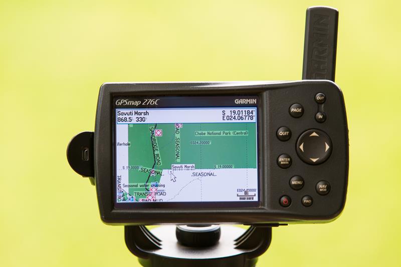
Around 2004 the GPSMap 276c was released. This GPS finally ticked all the boxes and a legend was born. It was expensive but people did not mind paying for something that did the job well. After it was discontinued in 2009 enthusiasts hung onto it and replaced the batteries rather than buy a more modern unit.
Back in those days there were no smartphones or tablets to compare to the standalone GPS; now we have various options and the truth is that you can buy two iPads for the price (R12 699) of a new GPSMap 276Cx. However, the latter offers you much more in terms of navigational features.
Features of the GPSMap 276Cx
- It has a very sturdy mounting bracket with bare wires, i.e. you need to wire it to your 12v power supply. You also have the option to use the USB cable to charge it but for permanent use in one location the wired connection is better.
- It has a Lithium-ion rechargeable battery pack which is a huge improvement and also comes with an AC charger.
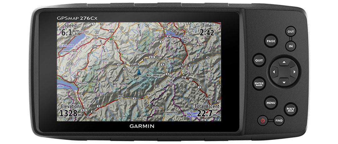
- The GPS case is somewhat different and larger than the old 276C with a 5 inch screen whereas the screen of its predecessor was less than 4 inches.
- The resolution is 800×480 with a bright sunlight readable screen. This is a big improvement over the older unit and a really massive transformation on the Montana which was considered the 276C replacement for many years. The new 276Cx can now compare favourably with the likes of new city navigators in terms of screen size and brightness.
- The old-school buttons of the 276C has been retained. It may come as a bit of a shock to people who are used to a touch screen, but once you get used to the buttons they are great. If you find yourself in a menu which you wish to exit, just hit the quit button until you are back on familiar ground. The only time when swiping the screen is really preferable, is when you pan the map.
- The unit weighs in at around 450g which makes it too heavy for use on foot or on the mountain bike. To make space for the larger screen the unit now measures around 190x 95x45mm. It is big but still much smaller than an iPad Mini and you will enjoy the bigger screen.
- The old 276C used a proprietary memory card which was bomb proof but expensive and limited in capacity. This has been replaced by a micro SD card slot which accepts your Tracks4Africa SD card and is located inside the battery compartment making it very secure.
- It has an IPX7 water rating so it can take splashes, rain, snow or incidental exposure to water of up to 2 meters deep for up to 30 minutes.
- It supports WiFi, Bluetooth and ANT; all new features which owners will be keen to explore. The user manual makes mention of notifications from your smartphone, weather updates and the ability to share your location while connected.
- The unit comes with a high sensitivity GPS receiver, barometric altimeter, electronic compass and 8GB of internal storage.
- As the GPSMap 276Cx has no built-in speaker you will not get voice prompts when you follow a route, as is the case with the Montana GPS.
- Track recording is a very important feature to Tracks4Africa as our maps are built from the actual track recordings of overland travellers. The previous 276C could only record 10 000 points on a track before it was full. This meant that you had to download data for an extended trip pretty much every evening or loose the older data as the track overwrote itself.
The new GPSMap 276Cx can record 20 000 points and, like all modern Garmin units, archives track data to a folder. Conveniently, you can access archived tracks from the menu, which is not possible on all GPS devices. This means you can go back a few days in your archive and select a track to view on your map.
As the unit comes with 8GB of internal memory it is unlikely that you will run out of recording space, even on extended trips.
How to operate the device
The unit is switched on with a red on/off button and it always opens on the Main Menu. To view the different screens simply keep pressing the Page button. If you want to get back to the Main Menu, hit the Menu button twice.
Zoom in and out with the In and Out buttons. Look for places by using the Find button, mark a waypoint by holding down the Enter button and when someone falls off the back of your bakkie you could use the MOB (man over board) button to quickly mark the spot.
For the full operating manual you can go to the Garmin site.
The GPSMap 276Cx has all the usual routing options. You can select various route calculation methods, for example shortest distance, fastest time or direct routing (ignoring the roads on the map). You can set up avoidances and deactivate lock on road (LOR). It also has a Trackback function to route you back to the starting point of your track.
The default settings of the GPSMap 276Cx will require a few tweaks to get the most value from your Tracks4Africa maps. We shall post a separate article soon on how to set it up.
As further background, see this article regarding the ideal GPS for overland travel using Tracks4Africa’s maps. Also look under the ‘Navigation’ menu on the T4A blog for other informative articles.

Hi all. I find my new 276 frustratingly slow, in comparison with it’s predecessor. Is there someone that can assist with this?
Hi,my 276cx freezes when i search under lodgings. I have Tracks for A 18.05 and OSM loaded.The unit is 3 days old.Help please!
I have written a review about the 276cx. Although this is from the perspective of a mountain biker, I think all types of users will benefit from reading it. It focuses on some aspects of the device which make it unusable for most users in my opinion. The article is here:
https://www.mtb-genuss.de/garmin-276cx/index.shtml
(Please note that this is a German website, but the article is in English)
Very interesting review and most issues are for use by a mountainbiker as against in offroad vehicle. I use a 1030 on my bike and want this for offroad vehicle so not so many problem for me. I would be interested to know if 18 moinths later Garmin have responded on any of these software issues thgough?
How can I get the grid locators used in amateur radio to show on the t4a maps – on the GPS and Basecamp?
Hi Neil, I am not familiar with the radio grid, however I assume its the Cartesian grid you are referring to. This type of information is not displayed on a GPS since the GPS inherently knows where you are and you can obtain your grid position at any time from the device. You can also scroll the map and click on it to obtain the grid reference for any location. The default format is WGS84 Lat/Long but you can set the format of your GPS to provide your grid reference in any format. You can contact me if you need more help with this.
Hi Eggie, the South Africa units are shipped with a topographical map of Africa which is based on OSM data. I am sure other enhancements were included as well, but it is not the City Navigator map which you will find on the Garmin Drive (Nuvi replacement) range.
Eggie, according to the Garmin website it comes preloaded with a worldwide basemap with shaded relief, as well as a subscription to BirdsEye Satellite Imagery2 to see real-life terrain views right on the device.
What maps, if any, are included with GPS276Cx?