Having a GPS is all good and well, but not every GPS will satisfy your needs. When you go out to buy yourself a GPS you have to consider carefully what you want to use it for. You will need a different GPS for a self-drive trip into remote areas than for other activities such as hiking, mountain biking or just normal city navigation.
As Tracks4Africa GPS maps are only compatible to Garmin GPS devices, all the devices mentioned below are Garmin.
Shop: Get Garmin GPS units and accessories from the T4A shop
Hiking or mountain biking
For hiking or mountain biking you have to look for a robust GPS that works with replaceable AA batteries, like the Oregon and GPSMap62 ranges. These don’t come with a city navigator map preloaded and do not give voice guidance but are great units for outdoor activities.
Travelling by motorbike
For travelling by motorbike you need a GPS that is water resistant and dust proof and you have to be able to read the maps in direct sunlight. The Zumo range is ideal.
Also read: Discover Baviaanskloof and 20 passes on a motorbike
City navigation
If you want a GPS for city navigation you should consider the Nuvi range. Any of the Nuvi models will do a perfect job to get you from point A to B and is easy to use and search for Points of Interest (POIs) around you. There is not much of a difference between the entry level units and the more advanced ones unless you specifically want features like lane assistance, 3D buildings and other city features.
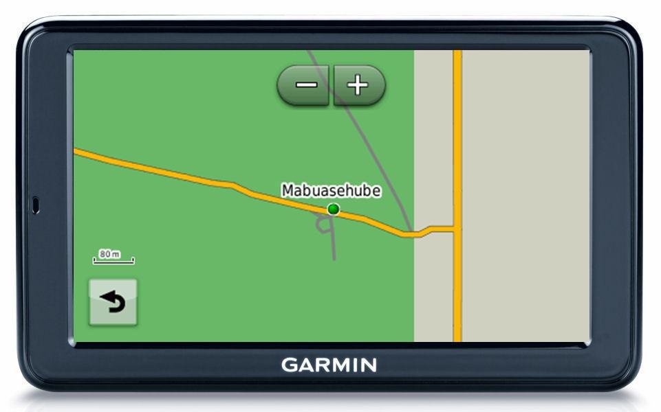
The Nuvi range only display road labels and points of interest (POI) on the map screen at low zoom levels (50m – 80m). The information is embedded in the T4A map and you will be able to search for it under “Where to” then “Points of interest (POI)” but it is not displayed at higher zoom levels when you look at the map under “View map”.
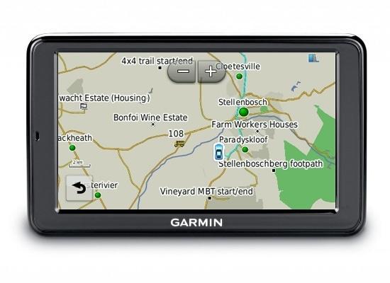
The Nuvi GPS at 2km zoom level.
The Nuvi range comes preloaded with a city navigator map and is very affordable.
You could also use the Tracks4Africa GPS map to navigate yourself to recorded POIs on our map. We cover campsites, fuel, lodging and a very extensive range of other features related to travellers on our maps. The further away you go from the cities the better our detail becomes.
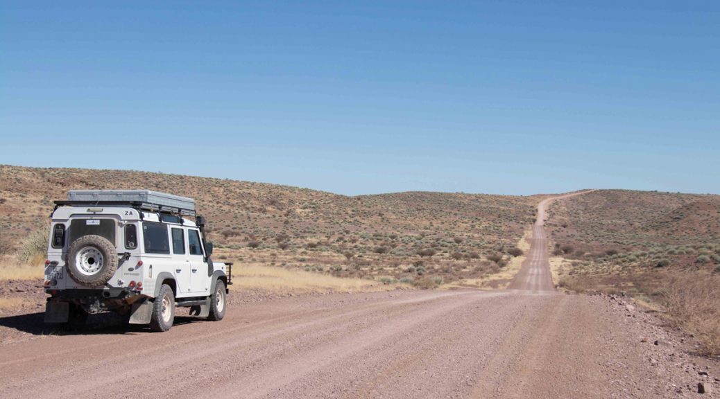
Travelling remote areas
If you are a self-drive traveller who wants to venture into the remote parts of Africa you must have a Garmin GPS with Tracks4Africa GPS maps. If you are going to use Tracks4Africa GPS maps and want to get the full potential from your navigation system you need a GPS that will display the map in a particular way otherwise you will not have all the information on the T4A maps at your disposal when you travel.
Also read: Essential travel tips for southern Namibia
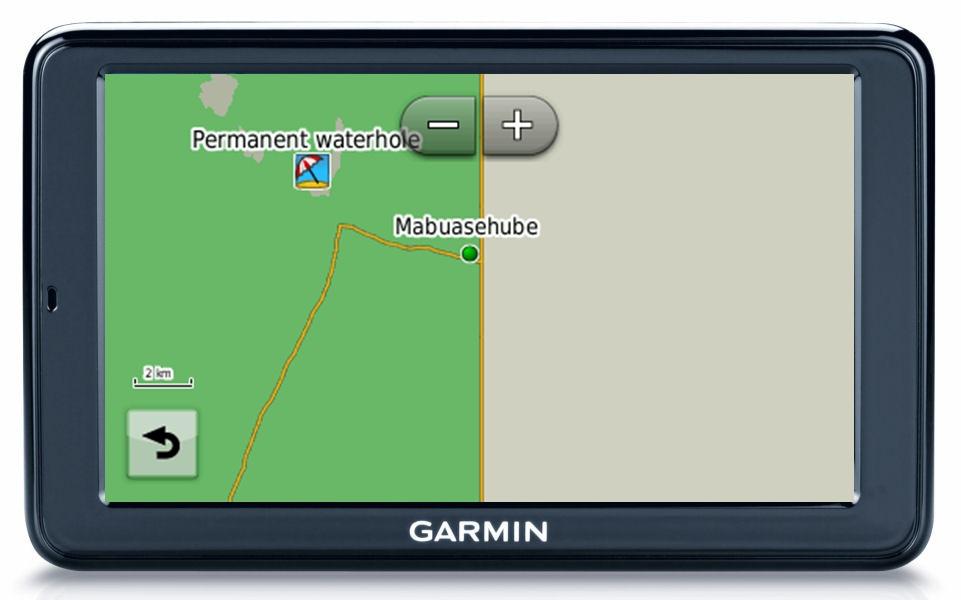
The Nuvi range is not ideal for travelling into remote areas as it does not display road labels and points of interest at high zoom levels. Our road labels carry information such as “off-road” or “deep sand” which is critical to your decision making. The map also carries POIs which provide additional information, for example seasonal flood warnings or dangerous sections on a trail. You would want to see this type of information on the map as you drive or when you plan a route.

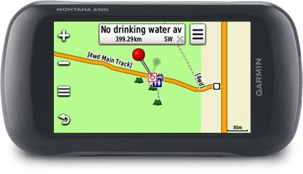
If you want to get the full benefit of your Tracks4Africa GPS maps, the outdoor devices are better than the automotive devices like the Nuvi range. Unfortunately the outdoor devices are more expensive and come with smaller screens.
GPS and trip log
If you intend to record your route with your GPS, then you need a GPS that can record and manage the tracks for the length of your trip. This is called trip log. This is handy if you want to trace back on a route you have just driven, but is only really necessary in the case of extreme off-road driving. GPS tracks can be used for your trip report afterwards and are very welcome at Tracks4Africa in order to update or improve our maps.
Also read: The Kalahari is not for sissies!
Beware, although some of the Nuvi models can record a track it does so in ‘lock on road’ (LOR) mode. This means that the track which is recorded will snap or lock onto the road on the map providing a false recording. The recording can only be used where there are no roads on the map or if the navigation mode is set to “offroad”. On the outdoor GPS units the LOR function can be disabled.
If you plan to venture into areas which are not covered in detail by the maps you have installed, then you might want to import tracks and waypoints to your GPS which can be used as a guide. This feature is normally only associated with outdoor type GPS units.
Also read: Smartphone vs GPS for navigation
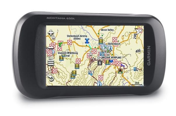
There is one Garmin model which offers all the right features for travelling into remote areas and it can be used for hiking, biking, motor biking or city navigation: the Montana. It is rugged, has a big enough screen and is a true outdoor GPS which displays all map features and allows superior track management. It is, however, an expensive device.
Did you know that all Tracks4Africa Africa GPS Map owners get one free update to the latest version, and 50% off any subsequent updates purchased? Go exploring with the most up-to-date map at your fingertips. Visit our online shop for our latest guide books, paper maps and GPS navigation.

Hi, is the DriveSmart 66 Bundle (GPS & 5-Year Tracks4Africa Map Updates) coming with loaded maps for Namibia? If not, please direct me to the link where I can purchase the complete bundle for a Namibian self-drive package. Thnks
Hi. The 5 Year map includes our full set of maps – covering the entire Africa – so it includes Namibia.
What GPS Garmin, T4A compatible would you recumbent to travel in remote places of Southern Africa.
Bertrand Hardy
Tracks4Africa’s Johann Groenewald answers the frequently asked questions about which GPS to choose: https://shop.tracks4africa.co.za/faq-category/gps/?fwp_faq_search=legend&fwp_faq_tags=garmin-gps
I have a Garmin drivesmart 55, are maps for southern africa pre loaded or do i have to download them
Hi Philip, you do not say in which region you bought the device. If you bought a unit in Southern Africa then the Garmin maps for that region would be preloaded. However if you bought the unit for example in Europe then European maps would have been preloaded and you would need to purchase the Southern Africa maps separately. The Tracks4Africa maps are independent from garmin maps and would need to be loaded to the device before you can use these. Hope this helps, else contact us via sales@tracks4africa.co.za
I am still using the older GPSMap76CSx with a micro SD card (about 12 x 8 mm in size). I had a 2GB SD Card with the full Southern Africa Topo & Rec maps on, but now also want to down load the full set of Tracks4Africa on ANOTHER 2GB SD card, but cannot find any 2GB SD cards at any shops anymore. I have tried one card which did not work (faulty card) and I do NOT want to erase my topo map set on the card (because I would like to chose between the map sets – topo or T4A). I have bigger SD Cards (4GB, 5GB, 16GB or 32GB) but none seems to work, for some obscure reasons (maybe my GPS is too old, bought in 2004, but still fully functional!!). It seems that my GPS will only read a SD Card of 2 GB or smaller. I tried a 128 MB card, which worked, but the full set of T4A are 370 MB +/- and I would like at least the whole set on one card (ie SD Card of 512MB to 2 GB). Is there anybody that can assist me with a Micro SD Card of these sizes (512 MB to 2 GB). I stay in Zululand, near Hluhluwe. Any help will be appreciated. Francois
Hi Francois, yes I think you are correct that the older units did not support SD cards bigger than 2Gb (that was a mighty big card back in those days). We should have a few 2Gb cards in the office and can make a special one for you. I will send you a mail about this as well.
Hi There – I have a Garmin Quest 2, it has T4A loaded, will I be able to update the maps BMO the online purchase to download the latest version.
Regards David
Hi David, I emailed you some questions. But in essence the maps should work however you need to be able to communicate between Quest and a PC in order to transfer maps and then the Quest has a limited memory. So you may only be to load a few regions at a time.
Is Garmin Nuvi 50 compatible to T4A maps?
Yes all of the Nuvi units are compatible with Tracks4Africa’s Garmin compatible maps
Hi,
Are the T4A maps compatible with Zumo 660?
Many thanks!
Feranando
Hi guys. Are the T4A gps maps compatible with the Garmin Overlander? Tks Reinier
Hi Reiner, sorry for the late reply, but yes T4A maps will work on the Overlander. Older SD cards may not show up but our 19.10 version is definitely compatible – I tested one on a long trip just now. If you want to transfer older maps from Basecamp to the Overlander, note that the Overlander only supports Windows and not Mac.
Thanks Johann. I bought the latest Africa map and havent been able to upload it into my Overlander via Garmin Explore. Basecamp doesnt seem to be really compatible with the Overlander (could be user error though). im at reinier@lifacommunications.com if you want to sharethe walk through? Thanks!
Hi. Is have a new Garmin 40lm. I have 2015 Tracks4Africa. It is not seeing it in the device no matter what I’d do. But a 2019 version is working. Help.
Billy can I ask you please send your support question to sales@tracks4africa.co.za
many thanks!
Its really nice and informative, Thank you for this article!
I have just acquired a new LR Discovery 5 – can your SD cards be used with the onboard dual screen gps units in this vehicle. If not , I guess I will have to revert to a Montana – it would be beast to use the onboard gear 🙂
Hi Gary. Our standard SD Cards we sell are only compatible with Garmin GPS hand held units. Tracks4africa may already be included in your in-car navigation system – if you are not sure check with Land Rover directly.
Hi, I’m looking at getting a Garmin DriveSmart 61 gps, in your article you mention that the Nuvi range and other automotive GPS aren’t as good as the outdoor ones because they don’t show as much detail such as road labels etc when zoomed out, do you know if this is still true with the DriveSmart 61? considering the display of the 61 is almost 7″ do you know if it would be able to display as much info as say the Montana range?
Thanks
Its really nice and informative, Thank you for this article!
I am Dian working with
Garmin GPS Support
Hello, did you test your SD card with model Garmin DriveSmart 61 LMT-S ? Is it compatible ?
Our SD Card GPS Maps are compatible with most Garmin units. It should be fine with that device, if you experience any problems then we will assist you.
Nice blog ThinkRace Technology also has been manufacturing GPS Trackers and providing product-based services to B2B Clients since 2006. Specializing in a wide array of GPS Products such as OBD Trackers, Vehicle Trackers, Kids Tracker, Fitness Tracker and GPS-enabled Smartwatches. In addition, OEM/ODM Services, Prototype Development, Cloud and Software Development Services also come under our forte.
To check the variety of products and services, visit ThinkRce Technology
LS, will the Garmin 50LMT-D be compatible with all of your maps?
Kind regards,
Anton
Hi Anton, yes it should be, that is all our GPS maps for Garmin unit.
Will the East Africa Maps work with a Garmin Drive 60?
We were informed that the Garmin DriveSmart 60LMT has been discontinued by Garmin, although they will continue providing support to this device. We have had a few problems by customers reporting to us that when inserting our SD card into this device, it keeps saying “Format SD card”….we are confident the problem is on the device and not on our software. We however cannot vouch for this problem on all Garmin DriveSmart 60LMT. Please refer to our FAQ no. 2 on our website for more info on compatible Garmin Devices. https://tracks4africa.co.za/support/faq/frequently-asked-questions-garmin-gps-unit/
hallo..does your map work with
Garmin DriveAssist™ 51 LMT-S for east africa region
Yes the Garmin DriveAssist™ 51 LMT-S is compatible with our maps.
Further question on this:
In the blog above it says “The Nuvi range is not ideal for travelling into remote areas as it does not display road labels and points of interest at high zoom levels. Road labels carry information such as “off-road” or “deep sand” which is critical to your decision making. ”
Does the Drive range of devices behave like the Nüvi in this respect, or will it display road labels and POI? I have a Drive 51 Central Europe LMT-S.
Hi Chris, yes the Drive range replaced the Nuvi range but it is essentially the same type of unit. It is also optimised for city use and will declutter the map automatically. Routing etc will work, its just not great at showing a lot of detail. But if you use your laptop with Basecamp for planning you can view all data upfront and make a decision on routes and then simply navigate with the GPS.
Thanks very much for the useful advice.
Hi Johann, do you know if the DriveSmart range would be any better at showing more detail? Specifically the DriveSmart 61 with its big screen?
Hi William, no to my knowledge these units are all displaying maps in a similar fashion. The bigger screen does not affect the way map data is displayed, it simply offers more space for a map view.
Thanks Johann for the info.
I am planning a self-drive trip to Botswana, for my next holidays and I need an advice in order to buy a right GPS where I can load T4A maps. The model are: oregon700/gpsmap62 range are the models in shop. Which one of them are more appropriate? Thank you
Hi Martin
Thank you for your interest in Tracks4Africa.
Tracks4Africa is compatible with most Garmin GPS units.
Examples of Compatible Garmin Devices: (ie. please note there are many more compatible Garmin Devices, these are just a few examples. Some may be outdated. All new Garmin Devices should be compatible with Tracks4Africa Maps).
Garmin BMW Motorrad Navigator
Garmin Edge Touring
Garmin eTrex 20 (is a good option, but the screen is a bit small)
Garmin eTrex 30 (is a good option, but the screen is a bit small)
Garmin NuviCam
Garmin Montana 600
Garmin Colorado 300
Garmin Nüvi 205W
Garmin Nüvi 3790
Garmin Nüvi 3760
Garmin Nüvi 2595
Garmin Nüvi 42LM
Garmin Montana 650t
Old Garmin GPSMap 276C (refer to our FAQ no. 51 further below ‘Using T4A GPS Maps on the Old Garmin GPSMap 276C’)
Garmin GPSMap 276Cx
Garmin Monterra
“Definitely on my bucket list!”
I have the Montana 650 and I’m having difficulties to find anything from Namibia on the GPS, I have T4A on it and also downloaded the whole Namibia maps (bought from T4A website) and still no luck, keeps telling me change the search parameters, can you maybe advise?
Wessel, our support staff will contact you asap.
Hi, I use the Zumo LM595 which is great with T4A on my bike. Is this also ideal for my 4×4 upcoming trip to Botswana, and will it be able to access all the T4A info features?
I have an old Garmin Nuvi 500. Will this model be as auseful and informative as the Montana????
Hi Pete,
It depends on what you want to use the GPS for. When travelling in the city most maps contain way too many points of interest (POIs) which clutter the GPS screen. For this reason most ‘city navigators’ such as the Nuvi devices will not show POIs on the screen, even though you can search for them. You have to zoom in to about 50 – 80m before the POIs will show up on the screen.
On the other hand the Garmin Montana is an outdoor GPS and it will show all POIs when you select view map. Both these units are compatible with Tracks4Africa maps and you will have the same information available under Where to > POI on the GPS’s.
I have a Oregon 450 GPS and are very happy in its performance in all areas. We did remote areas, hiking trails as well as city navigation and never have any problems. It is loaded with T4A as well as Garmin maps and we switch around as its demanded by the terrain.
Thanks for that advice, Theuns.